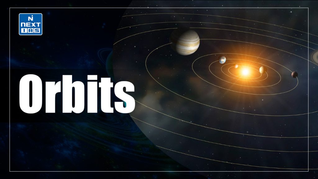
An orbit is the curved path an object follows around another due to gravity. Earth’s orbits include Low Earth Orbit (LEO), Medium Earth Orbit (MEO), and High Earth Orbit (HEO). Specialized orbits like polar, geostationary, and sun-synchronous serve communication, navigation, and observation purposes, optimizing satellite operations and data collection.
Types of Orbits
Low Earth Orbit (LEO)
- A low Earth orbit is an orbit that is relatively close to Earth’s surface. It is normally at an altitude of less than 1000 km but could be as low as 160 km above Earth – which is low compared to other orbits, but still very far from Earth’s surface.
- Earth observation satellites, also known as Remote Sensing Satellites use LEO as they are able to see the surface of the Earth more clearly by being closer to it. The International Space Station is placed at LEO.
Medium Earth Orbit (MEO)
- Medium Earth Orbit comprises a wide range of orbits anywhere between LEO and HEO (High Earth Orbit) — between 2,000 km and 35,786 km. It is very commonly used by navigation satellites, like the European Galileo System and Global Positioning System (GPS) constellation.
- All satellites in MEO have an orbital period of less than 24 hours, with the minimum period (for a circular orbit at the lowest MEO altitude) about 2 hours.
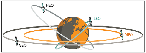
- The orbital periods of MEO satellites range from about two to 12 hours. Some MEO satellites orbit in near perfect circles, and therefore have constant altitude and travel at a constant speed. Other MEO satellites revolve in elongated orbits. The perigee (lowest altitude) of an elliptical-orbit satellite is much less than its apogee (greatest altitude).
- The orbital speed is much greater near perigee than near apogee. As seen from a point on the surface, a satellite in an elongated orbit crosses the sky in just a few minutes when it is near perigee, as compared to several hours when it is near apogee. Elliptical-orbit satellites are easiest to access near apogee because the earth-based antenna orientation does not have to be changed often and the satellite is above the horizon for a fairly long time.
Geosynchronous Orbit (GSO)
- About 35,786 kilometers above the Earth’s surface, satellites are in geostationary orbit. This distance puts it in the high Earth orbit category.
- A geosynchronous orbit synchronizes with the rotation of the Earth. More specifically, the time it takes for the Earth to rotate on its axis is 23 hours, 56 minutes and 4.09 seconds, which is the same as a satellite takes to complete one geosynchronous orbit.
- This makes geosynchronous satellites particularly useful for telecommunications and other remote sensing applications.
Geostationary Orbit (GEO)
- Geostationary orbit is a kind of Geosynchronous orbit. This is a circular orbit above the Earth’s equator, following the direction of the Earth’s rotation. It has an orbital period equal to the Earth’s rotational period (one sidereal day), and thus appears motionless, at a fixed position in the sky, to ground observers.
- Speed at which a satellite orbits the Earth coincides with the speed that the Earth turns and at the same latitude, however, this does not mean that the satellite and the Earth are traveling at the same speed, but rather than the satellite is traveling fast enough so that its orbit matches the Earth’s rotation.
- When a satellite is in geostationary orbit, its instruments are looking at a certain part of the Earth. That part of the Earth is called a footprint. For e.g. India, It is suitable for communication satellites, or meteorological (weather) satellites.
Semi-Synchronous Orbits
- Global Positioning System (GPS) satellites are in another sweet spot known as semi-synchronous orbits. While geosynchronous orbits match the rotation of Earth (24 hours), semi-synchronous orbits take 12 hours to complete an orbit.
- Instead of 35,786 kilometers above the Earth’s surface, semi-synchronous orbits are approximately 20,200 kilometers above the surface. This puts them in the medium Earth orbit range out of the three classes of orbits. These orbits are close to zero in eccentricity, meaning they are near-circular.
Polar Orbit
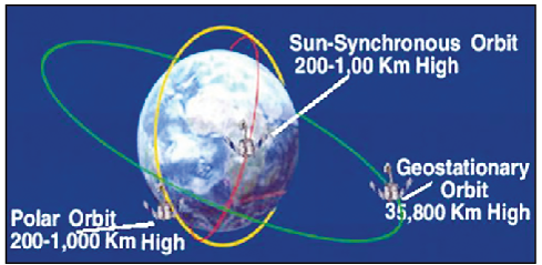
- A polar orbit travels north-south over the poles and takes approximately an hour and a half for a full rotation. As the satellite is in orbit, the Earth is rotating beneath it. As a result, a satellite can observe the entire Earth’s surface in the time span of 24 hours.
- Polar orbits have an inclination of about 90 degrees to the equator. Almost all the satellites that are in a polar orbit are at lower altitudes or in Lower Earth Orbit. They are often used for applications such as remote sensing, monitoring crops, forests and even global security.
Sun-Synchronous Orbit (SSO)
- When a satellite is in a Sun-synchronous orbit, it means that it has a constant Sun illumination through inclination and altitude.
- For Sun-synchronous orbits, it passes over any given point on Earth’s surface at the same local solar time. Because of the consistent lighting in sun-synchronous orbits, scientists leverage this in various remote sensing applications.
Transfer Orbit and Geostationary Transfer Orbit (GTO)
- A Hohmann Transfer is an orbital maneuver that transfers a satellite or spacecraft from one circular orbit to another. It is the most fuel efficient way to get from one circular orbit to another circular orbit. It is a two-impulse elliptical transfer between two co-planar circular orbits.
- The transfer itself consists of an elliptical orbit with a perigee at the inner orbit and an apogee at the outer orbit. The fundamental assumption behind the Hohmann transfer, is that there is only one body which exerts a gravitational force on the body of interest, such as a satellite.
- This is a good model for transferring an earth-based satellite from a low orbit to say a geosynchronous orbit. Inherent in the model is that there is no additional body sharing the orbit which could induce a gravitational attraction on the body of interest.
- Geostationary Transfer Orbit (GTO) is a type of Hoffman transfer orbit. The Geostationary Transfer Orbit is a highly elliptical orbit with a perigee of 180-200 km above the Earth’s surface and an apogee of around 35,900 km.
Uses of Different Orbits
- Low Earth Orbit (LEO)
- Earth Observation: Remote sensing satellites monitor climate, disasters, agriculture, and forests.
- Communication: Internet constellations (e.g., Starlink) provide high-speed connectivity.
- Space Research: The International Space Station (ISS) supports scientific experiments.
- Medium Earth Orbit (MEO)
- Navigation: GPS, Galileo, and other satellite-based positioning systems offer accurate location services.
- Communication: Some telecom networks use MEO for data transmission, balancing coverage and latency.
- Geosynchronous Orbit (GSO) / Geostationary Orbit (GEO)
- Telecommunications: Fixed satellites provide TV broadcasts, mobile networks, and satellite internet.
- Weather Monitoring: Meteorological satellites continuously observe large areas for weather forecasting.
- Polar Orbit
- Global Surveillance and Mapping: Satellites monitor Earth’s surface, including ice caps, forests, and crops.
- Environmental Monitoring: Track pollution, deforestation, and changes in the polar regions.
- Sun-Synchronous Orbit (SSO)
- Remote Sensing: Consistent lighting allows satellites to capture images under the same solar conditions daily.
- Scientific Research: Used for climate studies and environmental monitoring with high precision.
- Geostationary Transfer Orbit (GTO)
- Satellite Deployment: Serves as a pathway to move satellites from low orbits to higher ones like GEO efficiently.
These orbits enable critical applications in communication, weather forecasting, environmental monitoring, navigation, and space research.
Conclusion
Orbits vary based on altitude, inclination, and purpose. LEO supports Earth observation, MEO is ideal for navigation, and GEO/GSO enables stable communication. Polar and sun-synchronous orbits provide global and consistent coverage. Transfer orbits, like GTO, enable efficient movement between orbits, optimizing satellite deployment for specific applications such as weather monitoring and GPS.
GS - 3
