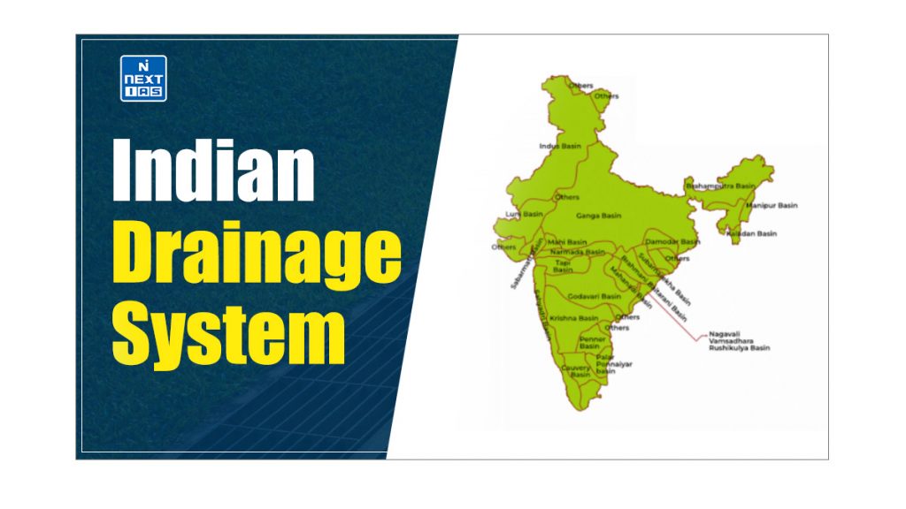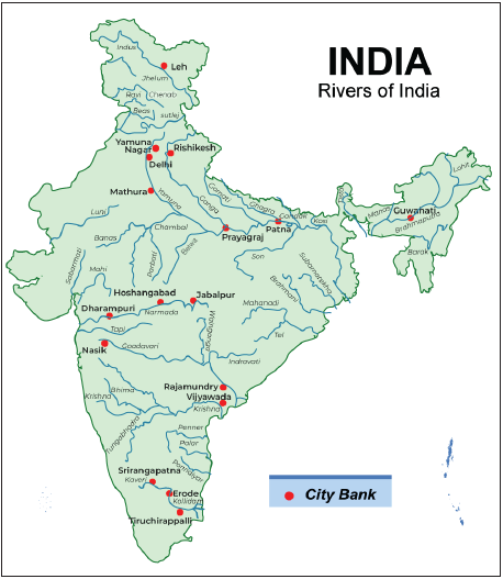
The Indian Drainage System encompasses an extensive network of rivers and streams that traverse the country’s diverse landscape. This intricate system plays a crucial role in shaping India’s geography, supporting its ecosystems, and providing essential resources for agriculture, industry, and daily life. This article aims to study in detail the Indian Drainage System, exploring its categorization, key features, various ways in which it is utilized and other related aspects.
About Indian Drainage System
- Most rivers discharge their waters into the Bay of Bengal, while some flow through the western part of the country and empty into the Arabian Sea.
- Also, the northern parts of the Aravalli range, some parts of Ladakh, and arid regions of the Thar Desert have inland drainage.
- All the major rivers of India originate from one of the three main watersheds:
- The Himalayas and the Karakoram Range,
- The Chotanagpur Plateau,
- Vindhyas and Satpura Range and
- The Western Ghats
Read our detailed article on Drainage System.
Categorisation of Indian Drainage System
The Indian Drainage System can be categorised into three groups:
- Drainage Systems Based on Origin,
- Drainage Systems Based on Type of Drainage,
- Drainage Systems Based on Orientation to the Sea
All these categorisations of the Indian Drainage System have been discussed in detail in the section that follows.
Drainage Systems Based on Origin
The Indian drainage system can be classified based on its origin into two parts:
- The Himalayan Rivers (Perennial Rivers): Indus, Ganga, Brahmaputra, and their tributaries.
- The Peninsular Rivers (Non-Perennial Rivers): Mahanadi, Godavari, Krishna, Cauvery, Narmada, and Tapi and their tributaries.
Drainage Systems Based on Type of Drainage
The Indian Drainage System or the river systems of India can be classified into four groups:
- The Himalayan Rivers,
- The Deccan Rivers, and
- The Coastal Rivers that drain into the sea and
- The rivers of the Inland Drainage Basin
| Note: – Streams like the Sambhar Lake in western Rajasthan are mainly seasonal in character, draining into the inland basins and salt lakes. – The only river that flows through the salt desert is the Luni in the Rann of Kutch. |
Drainage Systems Based on Orientation to the Sea
The Indian Drainage System based on the orientation to the sea are:
| Bay Of Bengal Drainage | Arabian Sea Drainage |
|---|---|
| Rivers that drain into the Bay of Bengal. | Rivers that drain into the Arabian Sea. |
| East flowing rivers. | West flowing rivers. |
| Nearly 77 per cent of the drainage area of the country is oriented towards the Bay of Bengal. | Nearly 23 per cent of the drainage area of the country is oriented towards the Arabian Sea. |
| The Ganga, the Brahmaputra, the Mahanadi, the Godavari, the Krishna, the Cauvery, the Penneru, the Penneiyar, the Vaigai, etc. | The Indus, the Narmada, the Tapi, the Sabarmati, the Mahi and a large number of swift-flowing western coast rivers descending from the Sahyadris. |

River Regimes
- The pattern of flow of water in a river channel over a year is known as its regime.
- Usually, fluctuations in the water flow of a river occur due to various factors such as melting, precipitation, formation of rocks or other relief changes etc. resulting in different river regimes.
- For example, the regimes of Himalayan rivers are different from peninsular rivers.
- Usually, fluctuations in the water flow of a river occur due to various factors such as melting, precipitation, formation of rocks or other relief changes etc. resulting in different river regimes.
- The Himalayan rivers are perennial as they are fed by both rainfall and glaciers and are said to be of glacial regime whereas the Peninsular rivers are fed only by the rainfall and thus subjected to fluctuations in the water flow depending on the amount of rainfall and said to be of the monsoonal regime.
- The rivers with the monsoonal regime have minimum water flow from January to May and maximum water flow in the monsoon season from June to September.
- For instance, the Narmada River has minimal discharge from January to July but experiences a sharp increase in August, reaching its peak flow. The decline in October is as dramatic as the August rise.
Utilization of River Water in India
The water from the river used for the following purposes:
- Irrigation – The river carries 45% of the total precipitation but because of uneven topography and flow characteristics all of it is not usable.
- And above 45%, only 33% of the annual flow is available for irrigation.
- Hydro-electricity – Large rivers in mountainous regions has great hydro-electricity potential.
- However, power generation from the peninsular river requires the impounding of water during monsoon months whereas the Himalayan river does not have such a problem as their flow is appreciable even during the critical winter months.
- Furthermore, they have other difficulties in the construction of large storage due to narrow valleys, high siltation, high seismicity in the region and vast alluvial plains with no variation in relief.
- Waterways – The country has one of the longest navigable rivers.
- The most important navigable rivers are Ganga, Brahmaputra, Mahanadi etc.
- Water Supply: The river water is used for agriculture, and water supply to cities, villages, and big industries.
- Unfortunately, the quality and quantity of water in the river are being eroded due to the discharge of sewage and effluents in the river and diversion of water respectively.
- Fishing: About 50% of the country’s total fish production comes from inland fisheries to which the river, its canals and its reservoir contribute the most.
- There is tremendous scope for an increase in freshwater fish production, with improvement in water quality and quantity in rivers.
Conclusion
The Indian drainage system is a complex and dynamic network that has played a pivotal role in the country’s development and sustenance. As the water demand continues to grow, it is crucial to manage this precious resource effectively, ensuring its equitable distribution and sustainable utilization. The preservation and responsible management of India’s drainage system will be instrumental in securing the country’s water security and promoting sustainable development for generations to come.
Difference between the Himalayan River System and the Peninsular River System
| Features | Himalayan River System | Peninsular River System |
|---|---|---|
| Origin | The Himalayan rivers originate from the high Himalayan ranges and are known as the Himalayan rivers. | The Peninsular rivers originate in the hills of the Peninsular Plateau and are called Peninsular Rivers. |
| Catchment Area | Himalayan rivers have large basins and catchment areas. | Peninsular rivers have relatively smaller basins and catchment areas. |
| Valleys | Himalayan rivers flow through deep, V-shaped valleys known as gorges. | Peninsular rivers flow through comparatively shallow valleys. |
| Drainage Type | Himalayan rivers exhibit antecedent drainage. | Peninsular rivers exhibit consequent drainage. |
| Water Flow | Himalayan rivers are perennial. | Peninsular rivers depend on rainfall, with flow occurring mainly during the rainy season. |
| Stage | Himalayan rivers are youthful, flowing through the Young Fold mountains. | Peninsular rivers, flowing through one of the world’s oldest plateaus, have reached a mature stage. |
| Meanders | Upon entering the plains, Himalayan rivers slow down, forming meanders and frequently shifting their beds. | Peninsular rivers, with their hard rock surfaces and non-alluvial nature, generally follow straighter courses with limited meandering. |
| Deltas & Estuaries | Himalayan rivers create large deltas at their mouths, with the Ganga-Brahmaputra delta being the largest in the world. | Some Peninsular rivers, like the Narmada and Tapti, form estuaries, while others, such as the Mahanadi, Godavari, Krishna, and Cauvery, form deltas. |
Frequently Asked Questions (FAQs)
Who invented drainage system in India?
The ancient Indian drainage system is credited to the Indus Valley Civilization, which flourished around 2500 BCE.
What are the four drainage pattern of India?
The four drainage pattern of India are:
a. Dendritic: Tree-like structure with river branches, common in the Peninsular region.
b. Radial: Rivers radiate outward from a central peak, seen in the Deccan Plateau.
c. Centripetal: Rivers converge towards a central basin, like in the Thar Desert.
d. Trellis: Parallel main streams with right-angle tributaries, found in folded sedimentary regions.


