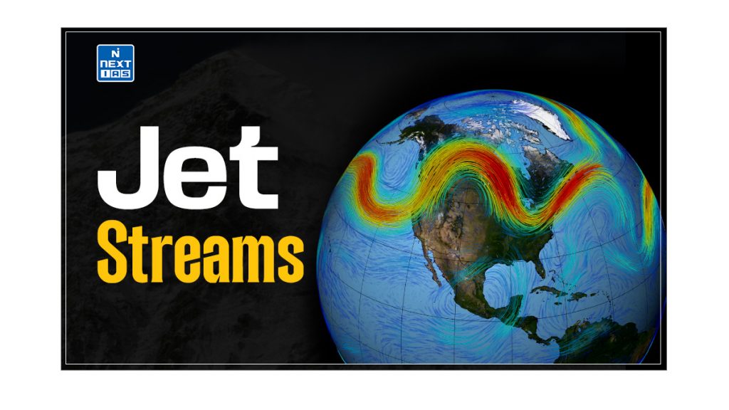
Jet Streams are crucial atmospheric phenomena that significantly impact global weather patterns. They play a pivotal role in shaping weather systems and influencing climatic conditions. This article aims to study in detail the characteristics of jet streams, their effects on weather patterns, and the role of various jet streams, including the westerly, tropical easterly, and Somali jets, in shaping the monsoon patterns and other weather conditions across different regions.
What are Jet Streams?
- Jet streams are narrow, strong wind bands that generally blow from west to east across the globe.
- They are found at heights ranging from 11 to 13 km above the surface of the Earth.
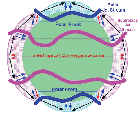
- The mean position of the stream in the Northern Hemisphere is between 20°N and 50°N latitude; the polar stream is between 30° and 70°N latitude.
- They are caused by great temperature differences between adjacent air masses.
- There are four major jet streams. Although discontinuous at some points, they circle the globe at middle and polar latitudes, both in each hemisphere.
- Instead of moving along a straight line, the jet stream flows in a wavelike fashion.
Characteristics of the Jet Streams
The salient characteristics of Jet Streams are:
- Narrow, Strong Wind Bands – Jet streams are narrow, strong wind bands that generally blow from west to east across the globe.
- Altitude Range – They are found at heights between 11 and 13 km above the surface of the Earth.
- Mean Position – The mean position of the stream in the Northern Hemisphere is between 20°N and 50°N latitude; the polar stream is between 30° and 70°N latitude.
- Cause – They are caused by significant temperature differences between adjacent air masses.
- Number and Continuity – There are four major jet streams. Although discontinuous at some points, they circle the globe at middle and polar latitudes, both in each hemisphere.
- Flow Pattern – Instead of moving along a straight line, the jet stream flows in a wavelike fashion.
Types of Jet Streams
There are several types of Jet Streams which are as follows:
Polar Jet Streams
- Polar Jet Streams are found between 50° and 70° latitude in both hemispheres, at altitudes of 7 to 12 kilometres, and can reach speeds of up to 250 kilometres per hour.
- They form at the boundaries between cold polar air and warmer mid-latitude air, generally being stronger in winter when the temperature contrast is greater.
Subtropical Jet Streams
- Subtropical Jet Streams are found around 30° latitude in both hemispheres, at altitudes of 10 to 16 kilometres, and can reach speeds of up to 150 kilometres per hour.
- They form at the boundaries between tropical and subtropical air masses and are most prominent in winter and early spring.
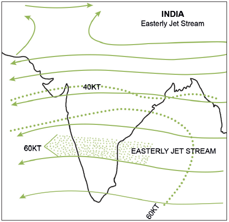
Tropical Easterly Jet Streams
- Tropical Easterly Jet Streams are found in the tropics, especially over the Indian Ocean and Africa. They typically occur between 10° and 20° latitude north, at altitudes of 12 to 17 kilometres.
- These jet streams form during the summer months due to the temperature gradient created when the land heats up more than the ocean, playing a crucial role in the monsoon circulation in South Asia.
Low-Level Jet Streams
- Low-level Jet Streams, found closer to the Earth’s surface at altitudes of 0.5 to 3 kilometres, can reach up to 80 kilometres per hour.
- They are most common at night and are often associated with severe weather events, such as thunderstorms and tornadoes, particularly in regions like the Great Plains of the United States.
Polar Night Jet Streams
- Polar Night Jet Streams are found in the polar regions, particularly in the stratosphere during winter, at altitudes of 20 to 30 kilometres.
- They can reach speeds of up to 300 kilometres per hour.
- They form due to the significant temperature difference between the dark polar regions and the sunlit areas at lower latitudes, influencing the dynamics of the polar vortex and the movement of stratospheric ozone.
Westerly Jet Streams
The Westerly Jet Stream can be explained under the following headings:
Position and Height of Westerly Jet Stream
- The upper air westerly jet streams are positioned in Asia at a height of about 12 kilometres in the Troposphere.
- These jet streams are bifurcated due to the mechanical barrier of the Himalayas and Tibetan Plateau during northern winter.
- One part flows to the north and the other to the south of the plateau.
Effects of Westerly Jet Stream on weather conditions
Since the westerly Jet moves in a wavy form, it creates cyclonic and anti-cyclonic conditions.
- Anti-cyclonic conditions are developed in the troposphere over Afghanistan, Pakistan, and north northwestern parts of India. These conditions result in descending winds over the northwestern parts of India, leading to atmospheric stability and dry conditions. This prevents the ascent of winds from the surface.
- Cyclonic conditions develop over the Tibet Plateau, where air rises.
Winter Weather Patterns
- In winter, rainfall is low due to stability, while some rains occur due to western disturbances brought to India by upper-air westerlies or jet streams. Winds blow from land to sea.
Summer Weather Patterns
- In summer, as the sun shifts from the southern to the northern hemisphere, the temperature starts rising in the north region of India. This weakens the south branch of the westerly jet stream, which gradually withdraws from India by the end of May.
- The equatorial trough pushes northwards with the weakening of the southern branch, leading to the movement of monsoon winds inside, and a burst of monsoon occurs. Hence, the Western Jet Streams have a crucial role in the onset of the monsoon in India.
Tropical Easterly Jet Stream
The Tropical Easterly Jet Stream can be explained under the following headings:
Position and Height of Tropical Easterly Jet Stream
- In summer, the Tibetan Plateau starts heating up, becoming a source of atmospheric heating. This heating generates an area of rising air.
- The ascending air is deflected to the right by the Earth’s rotation and moves in an anticlockwise direction, creating anti-cyclonic conditions in the upper troposphere.
Effects of Tropical Easterly Jet Stream on Weather Conditions
- Under the cyclonic conditions, the easterly winds that descend over the Indian Ocean intensify the high-pressure cell known as the Mascarene High.
- From this high-pressure cell, onshore winds blow towards the thermally induced low-pressure area in northern India, contributing to the formation of cyclonic conditions.
- Under the anti-cyclonic conditions, the Tropical Easterly Jet Streams (TEJ), originating from the Tibetan Plateau, move towards the Indian Ocean.
- These easterly jet streams are crucial for a strong monsoon in India. They help develop anti-cyclonic conditions in the upper troposphere and influence the distribution of monsoon rainfall.
Winter Weather Pattern
- The Tropical Easterly Jet Stream disappears with the onset of winter.
- The warming of Tibet and the development of TEJ are crucial for strong monsoon conditions in India.
Summer Weather Pattern
- If Tibet’s warming is less in a given year, the intensity of the monsoon is also reduced.
- The easterly jet stream helps steer tropical depressions into India, which play a significant role in the distribution of monsoon rainfall. The tracks of these depressions are areas of highest rainfall in India.
Somali Jet
- There are also temporary jet streams in addition to polar and subtropical jet streams, which are permanent jet streams.
- Temporary jet streams are narrow winds with speeds of more than 94 kph in the upper, middle, and sometimes lower troposphere.
- Two important temporary jet streams are the Somali Jet and the African Easterly Jet or Tropical Easterly Jet, which play a crucial role in the formation and progression of Indian Monsoons.
Somalian Current
- This current changes its flow direction due to upwelling and downwelling on the eastern coast of Africa.
- In winter, it flows from north to south from the coast of Arabia to the East African coastline.
- With the onset of the summer monsoon, it reverses direction, flowing from south to north.
- The progress of the southwest monsoon towards India is significantly aided by the onset of the Somali Jet, which transits Kenya, Somalia, and the Sahel.
- It strengthens the permanent high near Madagascar and helps drive the southwest monsoons towards India with greater pace and intensity.
Conclusion
In conclusion, jet streams, including the polar, subtropical, and temporary varieties like the Somali and Tropical Easterly Jet Streams, are fundamental to understanding atmospheric dynamics and weather patterns. These influential wind bands not only influence the distribution of rainfall and temperature but also play a critical role in the onset and intensity of monsoon systems. By examining their positions, effects on weather conditions, and interactions with other climatic factors, we gain valuable insights into the complex mechanisms driving global and regional weather patterns.
Frequently Asked Questions (FAQs)
What are Jet Streams?
Jet streams are fast-flowing, narrow air currents in the upper atmosphere, primarily near the tropopause. They are located at high altitudes and are formed by the temperature differences between the polar and tropical air masses.
How do jet streams affect the climate of India?
Jet streams significantly impact the climate of India by influencing the monsoon winds. The subtropical jet stream, in particular, affects the onset and withdrawal of the Indian monsoon. During summer, its northward shift allows the monsoon winds to bring heavy rains, while its southward change of winter leads to drier conditions. Additionally, western disturbances associated with jet streams bring winter rainfall to northern India.


