Applications of Space technology plays a vital role across various sectors, enhancing capabilities in communication, navigation, agriculture, disaster management, and environmental monitoring. Satellites provide critical data that supports weather forecasting, resource management, and connectivity, impacting daily life, economic growth, and security. These applications showcase space technology’s transformative potential on Earth.
About the Application of Space Technology in Different Sectors
- Technological and scientific advances in Space sector has provided many benefits to society on Earth in areas such as health and medicine, agriculture, transportation, public safety, defence consumer goods, energy and environment, disaster management and sustainable development, information technology, and industrial productivity, etc.
Agriculture Sector
- Agriculture is the backbone of Indian economy and the pivotal sector for ensuring food security. Timely availability of information on agriculture is vital for taking informed decisions on food security issues. India is one of the few countries in the world that uses space technology and land-based observations for generating regular updates on crop production statistics and providing inputs to achieve sustainable agriculture.
- Satellite-based optical and radar imagery are used widely in monitoring agriculture.
Major Highlights
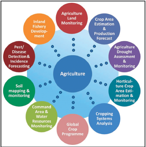
- Establishment of Mahalanobis National Crop Forecast Centre in Department of Agriculture & Cooperation, Ministry of Agriculture, Government of India, for operational use of space technology to provide in-season crop forecasts and assessment of drought situation; Crop production forecasting for 8 major crops; National agricultural drought assessment and monitoring; Country-wide agricultural land-use mapping; Agro-meteorological parameter retrieval and inputs to agro-advisory services; Methane emission inventory & carbon accounting.
Operational Products/Services
- Acreage and production estimates of 8 major crops (rice (Kharif & Rabi), wheat, mustard, jute, cotton, sugarcane, potato, sorghum) at district level periodic agricultural drought assessment in 13 States.
- Annual agricultural land-use mapping for crop intensification.
- Horticultural crop inventory, considering the importance of horticulture towards food & nutrient security including its export potential and economic benefits, a programme called ‘Coordinated programme on Horticulture Assessment & Management using geoiNformatics (CHAMAN)’ was launched in September 2014 by MoA&FW.
- Cropping system analysis.
- Satellite-based bio-geophysical products (vegetation index, rainfall, solar radiation) for agricultural crop monitoring and agromet-advisory services.
- Capacity building in remote sensing & GIS applications for sustainable agriculture.
Defence
- A 2000 kg satellite called GSAT-6 is used by the Indian Armed Forces. The GSAT- 6 is capable of streaming videos in both directions. This satellite was developed for defence surveillance, network-centric warfare and navigation.
- The launch of Radar Imaging Satellite 2 (RISAT-2) in 2009 is perhaps India’s first national security satellite discussed in the public domain. This satellite uses synthetic aperture radar developed by an Israeli company for providing radar images with a resolution of one meter regardless of the time or weather conditions over an area of interest.
- India also possesses world-class optical imaging satellites launched under the Cartosat series. Cartosat-1, launched in 2005, has a resolution of 2.5 metres. With the technological advances in this series, the currently operational Cartosat satellites can provide scene-specific images with a resolution better than 60 centimeters, along with the capability to capture one-minute video of the designated areas.
- The Indian Navy acquired its first dedicated communications satellite, GSAT 7, in 2013, while the Indian Air Force and the Indian Army are also set to acquire such satellites in the near future.
- In the recent Surgical strikes conducted by India inside enemy territory, ISRO’S roles was paramount in providing data, Visual and Intelligence.
- ISRO and DRDO launched EMISAT which is an Indian reconnaissance satellite developed under project Kautilya.
Rural Development
- Rural development involves overall development of rural areas with a view to improve the quality of life of rural people. It is a comprehensive and multidimensional concept and encompasses the development of agriculture and allied activities, village and cottage industries, socio-economic infrastructure, community services and facilities, and above all the human resources in rural areas.
Telecommunication
- INSAT satellites have been traditionally supporting telecommunication applications for providing voice and data communications. Satellite links are the primary means of connectivity to remote and far-flung regions of the country and they are the backup links for large number of terrestrial connectivity in the mainland. This helps in communication of rural people within themselves and with Urban areas at a faster pace.
Village Resource Centres
- To provide the space based services directly to the rural areas, ISRO/ DOS has launched the Village Resource Centres (VRCs) programme in association with NGOs/ Trusts and state/ central agencies. Over 6500 programmes have been conducted by the VRCs so far addressing the areas like, Agriculture/horticulture development; Fisheries development; Livestock development; Water resources; Tele health care; Awareness programmes; Woman’s empowerment; Supplementary education; Computer literacy; Micro credit; Micro finance; Skill development/vocational training for livelihood support etc. So far, over five Lakh people have used VRC services.
- The feasibility of incorporating advancements emerged in the area of communication technology into future VRCs is being studied. Based on the outcome of the study, utilization plan and interest of NGOs and State Governments, further expansion of VRC network would be considered.
Telemedicine
- Telemedicine is one of the unique applications of Space Technology for rural development benefit. ISRO Telemedicine programme started in 2001 has been connecting remote/rural/medical college hospitals and Mobile Units through the Indian satellites to major specialty hospitals in cities and towns.
- ISRO Telemedicine network covers various states/regions including Jammu & Kashmir, Ladakh, Andaman & Nicobar Islands, Lakshadweep Islands, North Eastern States and other mainland states. Many tribal districts of Kerala, Karnataka, Chhattisgarh, Punjab, West Bengal, Orissa, Andhra Pradesh, Maharashtra, Jharkhand and Rajasthan are covered under Telemedicine Programme.
Radio Networking
- Radio Networking (RN) through INSAT provides a reliable high-fidelity programme channels for National as well as Regional Networking. At present, 326 All India Radio (AIR) stations have been equipped with receive terminals. This specifically helps rural people who have wide access to Radio Networks.
Urban Planning
- ISRO has various plans to integrate Space Technology with Urban Planning. The technology augmentation and implementation for urban development is at the center of ISRO’s Long term Goals.
National Urban Information System
- The scheme is envisaged to meet the requirements for preparation of Master Plan / Development Plan, Transportation Plan, Urban Site Suitability Analysis and Urban Environmental Planning etc. High resolution satellite data and aerial data have been used to generate urban maps containing information such as land use, geology, soil, settlement locations for 152 cities/ towns in the country.
Governance
- Space technology derived inputs along with geospatial technologies and field information are being adopted in an integrated way by various Central Ministries and State Governments in planning, periodic monitoring, mid-course correction and evaluation of developmental activities. Large number of web and mobile based applications are deployed towards enabling e-governance and ease of doing business.
- These applications have benefitted the stakeholders by capturing time stamped & geo-tagged photographs and linking them to Bhuvan Portal for better monitoring of time schedules and ease in management of financial allocations of Public Benefit Schemes.
Economy
- Mineral exploration to utilise NMET (National Mineral Exploration Fund) in sound manner for exploration activities of alternative sources of energy. It can also help in mapping of mineral resources.
- India can reap lots of commercial benefits in future by launching other’s satellites and taking care of their space program by appropriately showcasing this mission.
- The biggest benefit of development in space technology is inspiring and creating new talent to take interest in space technology which will be crucial for India’s Economy.
- To meet the Civil Aviation requirements, ISRO has worked jointly with Airport Authority of India (AAI) in establishing the GPS Aided Geo Augmented Navigation (GAGAN) system. To meet the user requirements of the positioning, navigation and timing services based on the indigenous system, ISRO has established a regional satellite navigation system called Indian Regional Navigation Satellite System (IRNSS) or NaVIC.
- Disasters are prime disturbing elements for the economy of any nation. The services emanating from aerospace infrastructure, set up by ISRO, are optimally synthesized to provide data and information required for efficient management of natural disasters in the country.
Disaster Management and Sustainable Development
- India has been traditionally vulnerable to natural disasters on account of its geo-climatic conditions. Floods, droughts, cyclones, earthquakes and landslides have been recurrent phenomena. About 60% of the landmass is prone to earthquakes of various intensities; over 40 million hectares is prone to floods; close to 5,700 km long coastline out of the 7,516 km, is prone to cyclones; about 68% of the cultivable area is susceptible to drought.
- Development in space technology has helped reducing the harmful impacts of various disasters.
Flood
- India is one of the most flood prone countries in the world. Floods occur in almost all rivers basins in India. 23 of the 36 states and union territories in the country are subject to floods covering of above 40 million hectares of land, roughly one-eighth of the country’s geographical area.
- Assessment of the extent of flood affected areas and the damage to the infrastructure will enable the decision makers to plan for relief operations. Satellite based imageries due to their synoptic coverage are the best tool to assess the extent of flood affected areas. As soon as the information of a flood event is obtained, the earliest available satellite is programmed to collect the required data for the delineation of flooded areas.
Cyclone
- The major natural disaster that affects the coastal regions of India is cyclone. India has a coastline of about 7516 kms and it is exposed to nearly 10% of the world’s tropical cyclones. About 71% of this area falls in ten states (Gujarat, Maharashtra, Goa, Karnataka, Kerala, Tamil Nadu, Puducherry, Andhra Pradesh, Orissa and West Bengal). The islands of Andaman, Nicobar and Lakshadweep are also prone to cyclones.
Agricultural Drought
- With more than 70 percent of India’s population relying directly or indirectly on agriculture, the impact of agricultural drought on human life and other living beings is critical.
- In India, around 68% of the country is prone to drought in varying degrees. Of the entire area, 35% receives rainfall between 750 mm and 1125 mm, which is considered as drought prone and 33% receives rainfall less than 750 mm, which is considered to be chronically drought prone.
- Coarse resolution satellite data, which covers larger areas, is used to monitor the prevalence, severity level and persistence of agricultural drought at state/ district/ sub district level during kharif season (June to November).
Forest Fires
- Nearly 55% of the total forest cover in India is prone to fires every year. An estimated annual economic loss of Rs. 440 crores is reported on account of forest fires over the country.
- Forest fires in India have environmental significance in terms of tropical biomass burning, which produces large amounts of trace gases, aerosol particles, and play a pivotal role in tropospheric chemistry and climate. Active forest fires are detected from the satellite images and the information is uploaded daily to the Indian Forest Fire Response and Assessment System (INFFRAS) website during the forest fire season from February to June.
Landslide
- Remote sensing data have been proved to be useful for landslide inventory mapping both at local and regional level. It is also used for generating maps such as lithology, geological structure, geomorphology, land use / land cover, drainage, landslide scarp, etc.
- These maps can be combined with other terrain maps like slope, slope aspect, slope morphology, rock weathering and slope-bedding dip relationship in GIS environment to map the vulnerable areas for landslides.
- Department of Space has prepared Landslide Hazard Zonation maps (LHZ) along tourist and pilgrim routes of Uttaranchal and Himachal Pradesh, Himalayas and in Shillong-Silchar-Aizawl sector.
Read our detailed article on Landslides.
Earthquake
- Remote Sensing and GIS provide a database from which the evidences left behind by disaster can be combined with other geological and topographical database to arrive at hazard map.
- The area affected by earthquakes are generally large, but they are restricted to well known regions (Plate contacts). Satellite data gives synoptic overview of the area affected by the disaster. These data can be made use to create a very large scale base information of the terrain for carrying out the disaster assessment and for relief measures.
Renewable Energy
- India has a clear direction of utilising renewable energy for meeting the country’s requirements. Satellite remote sensing provides synoptic view, covering larger areas continuously for longer periods. Winds, solar and wave energy resources can be assessed with the help of Earth Observation data.
- Assessment of solar energy from Geostationary satellites like INSAT 3D & 3DR, ocean wind energy from Scatterometer data and ocean wave energy from Altimeter data & numerical models are being carried out. Monthly assured solar energy (kWhm-2) is derived using Kalpana-1 VHRR.
Forest & Environment
- Remote sensing data is used for varieties of applications in forestry and environment including Biodiversity characterization, Wetlands, Forest & Biomass mapping, Land Degradation and Desertification processes, Coastal wetlands, Coral reefs, Mangroves, Glaciers, Air and Water pollution assessment etc.
Geospatial Technology based Solutions
- Department of Space / ISRO is supporting various State Governments, by providing Geo-spatial tools and location based solutions to fight against COVID-19, including national level Corona virus tracker. At the same time, ISRO also made an attempt to study various impacts due to lockdown in terms of status of atmospheric parameters and water. The department carried out varieties of studies with different States using geospatial technology under Bhuvan Geoportal.
Way Forward
To maximize space technology’s benefits across sectors, India should foster greater private-sector partnerships, increase funding for innovation, and strengthen satellite infrastructure for areas like climate monitoring, agriculture, and disaster management. Expanding data-sharing frameworks and enhancing R&D will enable more effective applications, driving socio-economic progress and sustainable development.
Conclusion
Space technology has revolutionized sectors like agriculture, disaster management, communication, and environmental monitoring, enhancing efficiency, data accessibility, and resilience. Through satellite-based services and remote sensing, space advancements have become essential tools for economic development and societal well-being, showcasing the broad and transformative impact of space innovations on everyday life.
GS - 3
