The Indus River system, one of the three major river basins within the Himalayan drainage system, is a vital lifeline for the Indian subcontinent. The Indus River and its extensive network of tributaries support diverse ecosystems and human settlements, playing a crucial role in the cultural, agricultural, and economic landscape of the region. This article aims to study in detail the Indus River System, its origin, course, tributaries, and other related aspects.
About Indus River System
- The Indus River system is one of the three major river basins that comprise the Himalayan drainage system.
- The Indus River System and its numerous tributaries flow through the western part of the Indian subcontinent, carving deep gorges and sustaining diverse ecosystems along its course.
- With a total length of over 3,000 kilometres, the Indus is the longest river in Pakistan and one of the longest in Asia.
Origin of Indus River
- The Indus River originates from a glacier near Bokhar Chu in the Tibetan region in the Kailash Mountain range near the Mansarovar Lake.
- The river flows northwest and enters the Ladakh region of India at a place called Demchok.
- Once in India, the Indus River flows between the Karakoram and Ladakh ranges.
- In Tibet, it is known as ‘Singi Khamban,’ or the Lion’s Mouth.
Course of Indus River
- The Indus River is joined by the Zaskar River at Leh and then by the Shyok River.
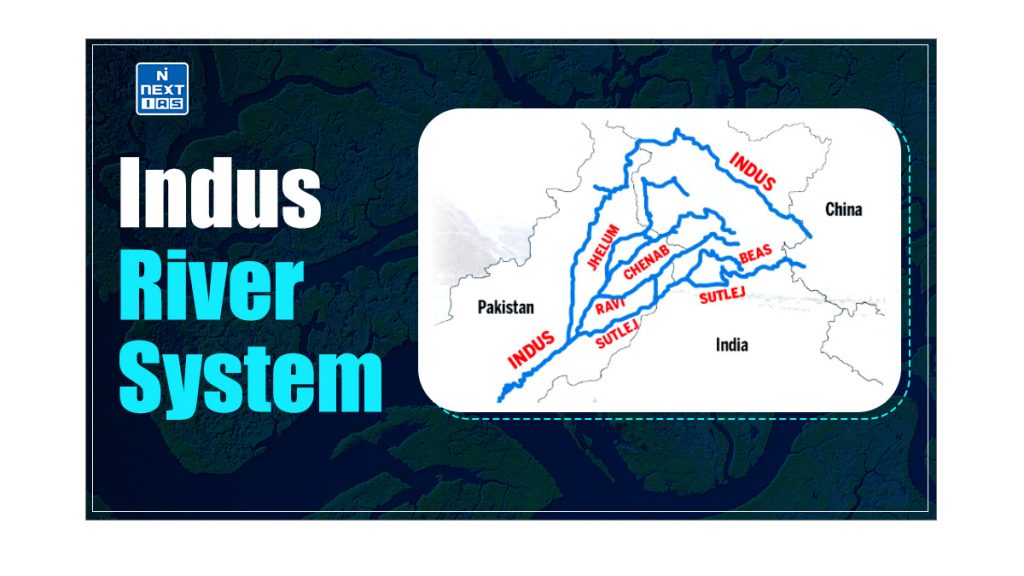
- Just above Mithankot, the Indus River receives the combined waters of the five eastern tributaries—the Jhelum, Chenab, Ravi, Beas, and Satluj—from the Panchnad.
- In the Sindh Province, the river gathers significant sediment, forming the Indus River delta before draining into the Arabian Sea near Karachi.
| Note: – The blind Indus River Dolphin, a sub-species of dolphin, is found exclusively in the Indus River. – The Indus flows through India only in the Leh district of the Union Territory of Ladakh. |
Tributaries of Indus River
The Left Bank Tributaries and Right Bank Tributaries of the Indus River are mentioned below:
Left-bank Tributaries
The Left Bank Tributaries of the Indus River are as follows:
- Zaskar River,
- Suru River,
- Soan River,
- Jhelum River,
- Chenab River,
- Ravi River,
- Beas River,
- Satluj River, and
- Panjnad River.
Some important left-bank tributaries of the Indus River System have been discussed in detail in the section that follows.
Zanskar River
- The Zanskar River is one of the important left-bank tributaries of the Indus.
- Human settlements are sparse here.
Chenab River
- The Chenab River originates near the Bara Lacha Pass in the Lahul-Spiti region of the Zaskar Range.
- It is formed by the confluence of the Chandra and Bhaga rivers at Tandi in the upper Himalayas of the Lahul and Spiti District in Himachal Pradesh.
- In its upper reaches, it is also called the Chandrabhaga.
- It flows through the Jammu region of Jammu & Kashmir to the plains of Punjab in Pakistan.
Jhelum River
- The Jhelum River, a tributary of the Chenab River, originates from a spring at Verinag at the foot of the Pir Panjal in the southeastern part of the Kashmir Valley in India.
- The Kishanganga (Neelum) River, its largest tributary, joins it there.
- The Chenab merges with the Sutlej to form the Panjnad River system which joins the Indus River at Mithankot and it ends in a confluence with the Chenab in Pakistan.
Ravi River
- The Ravi River originates from the Dhauladhar Range of the Himalayas in the Chamba district of Himachal Pradesh.
- Ravi has its source in Kullu hills near the Rohtang Pass in Himachal Pradesh.
- The major multipurpose project built on the river is the Ranjit Sagar Dam. Chamba town is situated on the right bank of the river.
Sutlej River
- The Satluj River is an antecedent river and is sometimes known as the Red River.
- It rises from beyond the Indian borders on the southern slopes of the Kailash Mountain near Mansarover Lake from Rakas Lake.
- In Tibet, it is known as Langchen Khambab.
- It enters Himachal Pradesh at Shipki La and flows in the South-westerly direction through Kinnaur, Shimla, Kullu, Solan, Mandi, and Bilaspur districts.
- It leaves Himachal Pradesh to enter the plains of Punjab at Bhakra, where the world’s highest gravity dam- Bhakra Nangal Dam, has been constructed on this river.
- It is mainly used for power generation and many large canals draw water from it.
- Across the river, there are many hydroelectric and irrigation projects such as the Kol Dam, and Nathpa Jhakri project.
Beas River
- The Beas River is an important river of the Indus River System, which emerges from Rohtang Pass in Himachal Pradesh.
- The river before entering Pakistan merges with the Sutlej River at Hari-Ke-Pattan in Punjab.
- The city of Manali is situated on the right bank of the River Beas.
Right-bank Tributaries
The Right Bank Tributaries of the Indus River are as follows:
- Shyok River,
- Gilgit River,
- Hunza River,
- Swat River,
- Kunnar River,
- Kurram River,
- Gomal River,
- Tochi River, and
- Kabul River.
Some important right-bank tributaries of the Indus River System have been discussed in detail in the section that follows.
Shyok River
- The Shyok River rises from the Karakoram Range and flows through the Northern Ladakh region.
- It originates from the Rimo Glacier and the river widens at the confluence with the Nubra River.
- It marks the southeastern fringe of the Karakoram ranges by forming a V-shaped bend around it.
Nubra River
- The Nubra River is the main tributary of the Shyok River.
- It originates from the Nubra Glacier and the river meanders towards the southeast to join the Shyok River downstream of Shyok Valley at the base of the Ladakh range.
Conclusion
The Indus River system not only sustains vast ecosystems and supports millions of livelihoods but also stands as a testament to the intricate natural processes that shape our world. The river’s journey from the icy peaks of the Himalayas to the Arabian Sea is marked by its historical significance, ecological importance, and the ongoing challenges it faces due to climate change and geopolitical issues. Effective management and conservation efforts are essential to preserve this vital waterway, ensuring it continues to nourish the land and its people for generations to come.
Indus Water Treaty 1960
- The Indus Water Treaty of 1960 is a landmark agreement between India and Pakistan, brokered by the World Bank, to manage the shared water resources of the Indus River system.
- The treaty allocated the use of three eastern rivers (Ravi, Beas, and Sutlej) to India while granting Pakistan control over the three western rivers (Indus, Jhelum, and Chenab).
- This agreement has been hailed as one of the most successful water-sharing pacts in the world, providing a framework for cooperation and conflict resolution between the two nations despite their broader geopolitical tensions.
- It allows India certain non-consumptive uses and hydropower projects on the western rivers while ensuring downstream flow to Pakistan, thereby balancing the water needs and rights of both countries.
Frequently Asked Questions (FAQs)
Why is the Indus River important?
The Indus River is important for its vital role in agriculture, providing irrigation to one of the world’s largest contiguous irrigation systems. It supports the livelihoods of millions in India and Pakistan, serves as a crucial water source, and has significant historical and cultural importance, being the cradle of the ancient Indus Valley Civilization.
What is the length of Indus River?
The Indus River is approximately 3,180 kilometers long.
Indus River originates from which glacier?
The Indus River originates from the Mansarovar Glacier in Tibet.