The coordinates used in locating places on Earth are latitudes and longitudes. Latitudes stand for the measure of how far north or south of the equator a place is; meanwhile, longitudes tell us how far east or west of the Prime Meridian a place is. Time zones are standard time regions broken into segments from Earth’s rotation vis-à-vis the Greenwich Meridian.
About the Latitudes, Longitudes & Time Zones
- It is a geographical coordinate system for specifying location(s) on Earth.
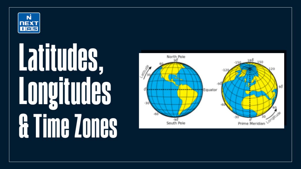
- Latitude lines run horizontally and measure distances north or south from the Equator, wherein the latitudinal value begins at 0° from the Equator and increases toward 90° at the poles.
- Longitude lines are vertical lines measuring distances east or west from the Prime Meridian, which lies at 0° longitude and runs through Greenwich, England.
- A particular location on the Earth is defined through the unique combination of these coordinate pairs, allowing navigation, mapping, and geographic research to be performed.
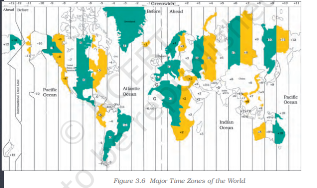
- Time zones are associated with longitude and the rotation of the Earth. Since the Earth rotates through 360° in 24 hours, it is divided into 24 time zones, each occupying a space of 15° of longitude.
- The Prime Meridian acts as the reference for Coordinated Universal Time (UTC), and other time zones are determined as time offsets from UTC.
- Such a system preserves consistency in marking time around the globe, being extremely necessary for travel, communication, and international cooperation, the markings reflecting Earth’s topography and rotation.
Diagram of Latitudes and Longitudes & Time Zones
Significance of Latitudes, Longitudes and Time Zones
Latitudes, longitudes, and time zones are essential concepts in geography and cartography, playing crucial roles in navigation, mapping, and understanding Earth’s spatial relationships. Here’s their significance:
Latitudes
- Definition: Latitudes are horizontal lines measuring how far north or south a place is from the Equator, stated in degrees (°). At the Equator, the latitude is 0°, while at the two poles, it is 90°N at the North Pole and 90°S at the South Pole.
- Significance:
- Climatic Zones: They divide the Earth into climatic zones, such as the tropical region (between the Tropic of Cancer and Tropic of Capricorn), temperate region, and polar region.
- Navigation: Used to determine a location’s position relative to the Equator.
- Daylight Variations: Determine variations in sunlight received; hence, they affect the seasons and duration of daylight.
Longitudes
- Definition: Longitudes run in a vertical direction measuring the distance east or west of the Prime Meridian, stated in degrees. The Prime Meridian (0°) runs through Greenwich, England, and the opposite meridian, the 180° meridian, serves as the International Date Line.
- Significance:
- Time Calculation: Longitudes help determine local time as per Earth’s rotation (15° longitude equals one hour).
- Positioning: Together with latitudes, they locate the exact position on Earth’s surface.
- Navigation and Cartography: They are indispensably used for map-making and steering ships, aircraft, and vehicles.
Time Zones
- Definition: Time zones are Earth’s regions divided in terms of the mean solar time at a supposed central longitude (usually multiple of 15° east or west from the Prime Meridian).
- Significance:
- Standard Time: Time zones regulate time at a local level, allowing international communications and travel to pass smoothly.
- Coordinating Economic Activities: They help coordinate activities across countries, such as trade, transport, and broadcasting.
- Daylight Saving: In some regions, time zones undergo seasonal adjustments in improving daylight utilization.
Interconnections
- Latitudes and Longitudes: They are two half-geographic coordinate systems with which any location on Earth can be pinpointed.
- Time Zones and Longitude: Time zones correspond with longitudes, where one time zone usually constitutes 15 degrees of longitude.
Knowledge about these elements is important for navigation, understanding the geography of the Earth, international communication, and also further investigating spatial phenomena.
Applications of Latitudes, Longitudes and Time Zones
The applications of latitudes, longitudes, and time zones are extensive, spanning multiple fields such as navigation, meteorology, global communication, and technology. Here’s how they are applied:
Applications of Latitudes
- Climate Studies
- Set climatic lines: tropical, temperate, polar.
- Weight weather patterns against the effect of global warming with latitude-specific data.
- Agriculture
- Set parameters for crop suitability in certain zones on a latitude basis, e.g., temperature, sunlight.
- Astronomy and Solar Energy
- Solar rays’ incidence angle calculation for panel installation.
- Assess seasonal daylight changes.
- Tourism and Exploration
- Advice travelers on the best time for visiting these zones demarcated according to latitude (e.g., Aurora in the Arctic Circle).
- Applications of Longitudes
Applications of Longitudes
- Navigation
- Employed by GPS systems to define the east-west coordinate of any place.
- Support maritime navigation and aerial navigation.
- Timekeeping
- Used in calculating local time as well as in determining time difference across the globe.
- International Boundaries
- Set territorial limits between various countries and regions.
- Earthquake and Geological Studies
- Derive longitudinal positions of tectonic plate boundaries and earthquake epicenters.
Applications of Time Zones
- Global Communication
- Schedule international calls, meetings, and broadcasts by considering time differences.
- Transportation and Logistics
- Facilitate global air and sea travel by standardizing departure and arrival times.
- Coordinate international shipping schedules.
- Economy and Trade
- Optimize stock market operations and trading hours across continents.
- Astronomy and Space Exploration
- Schedule space launches and satellite operations based on local time zones.
- Technology
- Enable accurate functioning of time-sensitive systems like servers, cloud computing, and financial transactions.
- Entertainment and Sports
- Align international sports events, TV shows, and online gaming activities with diverse time zones.
Interdisciplinary Applications
- Geographic Information Systems (GIS)
- Combine latitude, longitude, and time data for mapping and spatial analysis in disaster management, urban planning, and resource allocation.
- Education and Research
- Study Earth’s physical and cultural geography.
- Develop models to understand the Earth’s rotation and seasonal variations.
- Military and Defense
- Plan strategic movements and coordinate operations globally.
- Environmental Monitoring
- Track pollution patterns, deforestation, and ocean currents using latitude-longitude grids.
By integrating latitudes, longitudes, and time zones, modern technology and systems achieve high precision and efficiency in various sectors.
Way Forward
The way ahead is integration of the latitudes, longitudes, and time zones with newer technologies such as Artificial Intelligence and the Internet of Things for precision mapping and monitoring, environmental study, and global communication. With improved GIS systems, real-time data sharing, and smart systems, navigation, climate study, and international cooperation would be set in place, solving issues of sustainability, urban planning, and global connectivity.
Conclusion
Latitudes, longitudes, and time zones are essential to distinguish Earth’s geography, navigation, and time organization. They are used in location mapping, for global communication, and for time management. Their uses extend to several different fields, such as transport, climate studies, and technology; hence, they are essential in coordinating human activities on an international level and promoting global connectivity.
Frequently Asked Questions (FAQs)
What are latitude and longitude?
Latitude refers to the angular distance north or south of the Equator, measured in degrees. Longitude is the angular distance east or west of the Prime Meridian. Together, they form a coordinate system to locate positions on Earth.
What are the latitudes and longitudes of India?
The latitude of India ranges from 8°4’N (southernmost point) to 37°6’N (northernmost point). The longitude ranges from 68°7’E (westernmost point) to 97°25’E (easternmost point), covering a vast geographical expanse in South Asia.
What is the difference between latitude and longitude?
Latitude measures the distance north or south of the Equator in degrees, running parallel to it. Longitude measures the distance east or west of the Prime Meridian in degrees, converging at the poles. Both define Earth’s coordinates.