The Navigation with Indian Constellation (NaVIC) is India’s indigenous satellite-based navigation system, developed by ISRO to provide accurate positioning across India and the surrounding region. Designed to enhance regional navigation independence, it supports diverse applications, including navigation, disaster management, and fleet tracking, while reducing reliance on global systems like GPS. This article aims to study the Navigation with Indian Constellation (NaVIC).
About the Navigation with Indian Constellation (NaVIC)
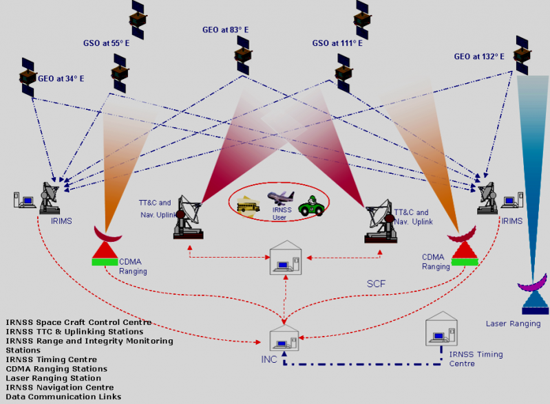
- The Indian Regional Navigation Satellite System (IRNSS), developed by the Indian Space Research Organisation (ISRO), is an independent regional navigation system for India. IRNSS aims to establish a regional satellite navigation network using a combination of geosynchronous (GEO) and geostationary (GSO) satellites, along with advanced ground systems.
- Coverage Area: The IRNSS-NavIC system is designed to provide precise position information within India and an area up to 1,500 km beyond its borders, which is designated as the primary service area. An extended service area reaches between the primary coverage area and the larger region bordered by 30° South to 50° North latitude and 30° East to 130° East longitude.
- NavIC Network: It includes a constellation of seven satellites, complemented by a robust ground infrastructure operating continuously. Three satellites are positioned in GSO, while four occupy inclined GEO slots. The ground segment comprises a control center, precision timing facilities, range and integrity monitoring stations, and two-way ranging stations.
- IRNSS Services: IRNSS offers two primary services:
- Standard Positioning Service (SPS) – available to all users.
- Restricted Service (RS) – an encrypted service accessible only to authorized users.
- The NavIC SPS signals are designed to be interoperable with other global navigation systems like GPS, GLONASS, Galileo, and BeiDou.
- Frequency Bands: The NavIC satellites currently use the L5 and S bands to deliver positioning data.
- Accuracy: IRNSS is expected to provide location accuracy within 20 meters in its primary service area.

Need of IRNSS – NavIC
The need for IRNSS-NavIC (Indian Regional Navigation Satellite System – Navigation with Indian Constellation) arose to provide India with an independent, reliable, and precise regional navigation system. Key reasons for its development include:
- National Security and Strategic Independence
- Relying solely on foreign satellite navigation systems, like the U.S. GPS, poses potential security risks, as access can be restricted or degraded during critical situations. An indigenous system like NavIC ensures that India has full control over its navigation services, providing secure and uninterrupted access, especially for defense operations.
- Enhanced Navigation Accuracy in the Region
- NavIC is specifically designed for India and surrounding areas, offering enhanced positioning accuracy tailored to the regional needs of South Asia. With an expected accuracy of better than 20 meters within its primary coverage area, NavIC serves as a more precise option for applications within this region compared to global systems.
- Support for Civilian Applications
- NavIC supports a range of civilian applications, such as transportation, agriculture, disaster management, and marine navigation. With location-based services like fleet management, railway tracking, and personal navigation. It facilitates efficient logistics and safety in transportation and other sectors.
- Disaster Management and Emergency Response
- NavIC’s reliable navigation services help during natural disasters by improving coordination in emergency response efforts. With location accuracy and continuous coverage, it enables better planning, monitoring, and communication in disaster-stricken areas, which is crucial for timely rescue and relief operations.
- Regional Coverage Tailored for India
- NavIC’s coverage is focused on India and areas up to 1,500 km beyond its borders, effectively serving India’s needs without depending on global systems with more extensive, non-specific coverage. This regional design is cost-effective and optimized for India’s geography and strategic interests.
- Interoperability with Global Systems
- NavIC’s compatibility with other global navigation systems (GPS, GLONASS, Galileo, BeiDou) enhances its usefulness and broadens its range of applications, enabling seamless navigation and improved accuracy when combined with these systems.
Advantages of Having an Indigenous Regional Navigation System
With the launch of IRNSS, India has joined a select group of nations with satellite navigation capabilities, offering several advantages:
- Self-Reliance
- It functions as an independent regional navigation system for the Indian subcontinent, eliminating reliance on foreign systems to provide positional services within its coverage area.
- Strengthening Regional Relations
- NavIC’s extensive coverage allows for potential data sharing and access with SAARC nations, fostering diplomatic goodwill and promoting the integration of regional navigation systems.
- Enhanced Accuracy
- With a fully operational NavIC, which includes ground stations in Japan, France, and Russia for improved signal triangulation, open signals can achieve accuracy within 5 meters, while restricted signals offer even greater precision compared to GPS, which typically has an accuracy of about 20 meters.
- Constant Monitoring
- Unlike GPS, NavIC utilizes satellites in geostationary orbit that maintain a fixed position relative to Earth, providing consistent coverage over the same areas. This constant monitoring enhances the operational capabilities of India’s armed forces, helping to bolster vigilance and prevent cross-border terrorism.
- Effective Signal Reception
- NavIC signals reach India at a 90-degree angle, improving signal reception in densely populated areas, dense forests, and mountainous regions.
- Complete Control
- The Indian government maintains full authority over the IRNSS-NavIC system, ensuring that navigation services align with national interests.
Applications of IRNSS – NavIC
IRNSS-NavIC (Indian Regional Navigation Satellite System) has a wide range of applications across various sectors due to its high accuracy and reliable navigation capabilities. Here are some key applications of NavIC:
- Transportation and Fleet Management
- Navigation for Vehicles: It provides real-time positioning data for vehicles, enhancing navigation and route planning.
- Fleet Tracking: Companies can monitor and manage fleets effectively, optimizing logistics and reducing operational costs.
- Aviation
- Air Traffic Management: It supports accurate navigation for aircraft, aiding in safe and efficient air traffic control and management.
- Precision Approaches: It assists in landing procedures and approaches in challenging weather conditions, improving safety.
- Maritime Navigation
- Shipping and Fishing Vessels: It enhances navigational accuracy for commercial shipping and fishing boats, improving safety and efficiency at sea.
- Coastal Surveillance: The system aids in monitoring coastal activities, helping in search and rescue operations and enhancing maritime security.
- Agriculture
- Precision Farming: Farmers can use NavIC for precise field mapping, soil analysis, and crop monitoring, leading to increased yields and efficient resource management.
- Automated Machinery: Tractors and other agricultural equipment can be guided accurately, optimizing farming operations.
- Disaster Management and Emergency Services
- Natural Disaster Response: It assists in planning and coordinating rescue operations during natural disasters by providing accurate location data.
- Emergency Services Coordination: It aids emergency services in reaching affected areas quickly and efficiently.
Way Forward
- The way forward for NavIC involves expanding its capabilities and integration into various sectors to maximize its potential benefits. Continued efforts to enhance the system’s accuracy and reliability are essential, including the establishment of additional ground stations and the development of next-generation satellites.
- Collaboration with neighboring countries and regional partners can foster data sharing and interoperability with other global navigation systems, enhancing regional navigation services. Furthermore, promoting the adoption of NavIC in emerging technologies such as autonomous vehicles, Internet of Things (IoT) applications, and smart city initiatives can drive innovation and economic growth.
- Ongoing research and development will also be crucial to explore new applications in sectors like agriculture, disaster management, and telecommunications. By investing in these areas, NavIC can solidify its position as a vital tool for India’s strategic interests and contribute significantly to the nation’s technological advancement and global standing in satellite navigation.
Conclusion
- NavIC represents a significant advancement in India’s satellite navigation capabilities, providing an independent and reliable system tailored to regional needs. Its applications span various sectors, including transportation, agriculture, disaster management, and defense, enhancing operational efficiency and safety.
- By ensuring accurate positioning and fostering regional cooperation, NavIC not only strengthens India’s self-reliance but also promotes goodwill with neighboring countries. Ultimately, NavIC paves the way for future innovations in navigation technology, contributing to India’s strategic and economic development.


