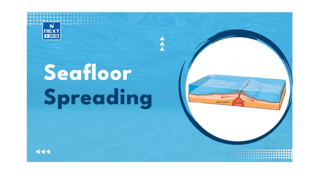
Seafloor Spreading is the usual process at work at divergent plate boundaries, leading to the creation of new ocean floor. This article aims to provide a comprehensive overview of the Seafloor Spreading and Ocean Floor Configuration.
What is Seafloor Spreading?
- It is a geological process responsible for the creation of the crusts, the outermost shell of Earth.
Harry Hess Advocated the Causes of Seafloor Spreading Theory
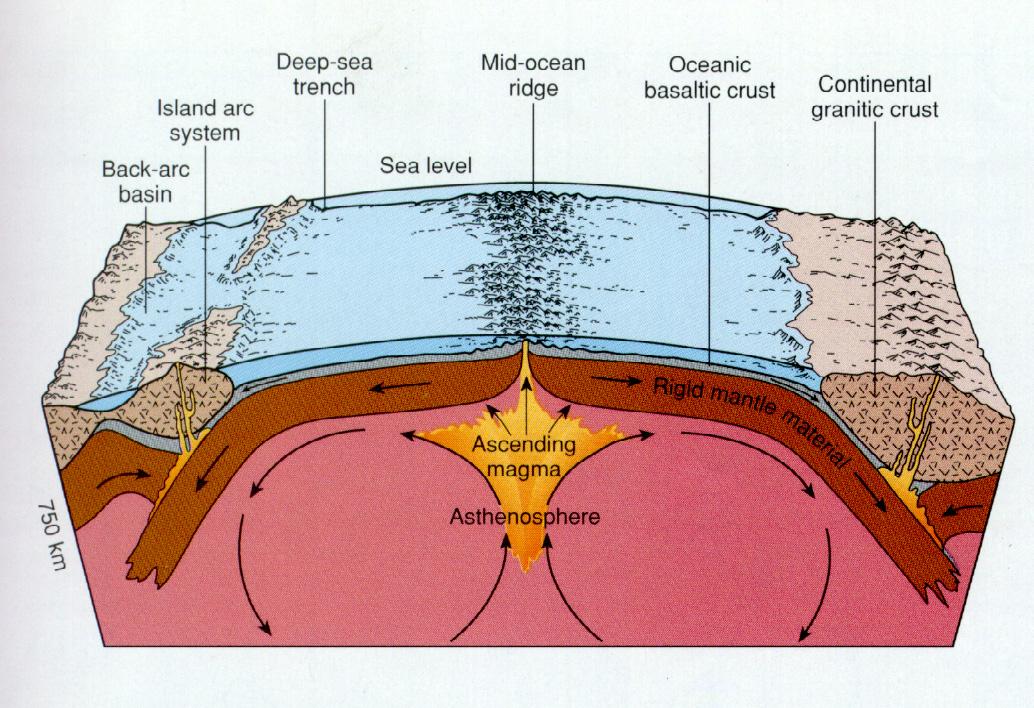
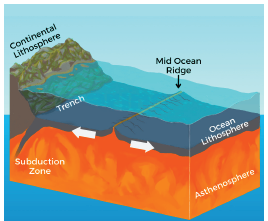
- According to the theory, the ocean floor is in constant motion, moving from the mid-oceanic ridge towards the trenches.
- At the ridge, hot basaltic magma rises and erupts, eventually cooling down and forming a new seafloor.
- Over time, this newly formed seafloor gradually moves away from the ridge, making room for newer seafloor to take its place, thus repeating the cycle.
- During this process, older rocks move further away from the spreading zone, while younger rocks are found closer to the spreading zone.
- The formation of new rocks occurs at the ridge, while older rocks collide with the continental crust at the subduction zone, which is located near the continental crust.
The Entire Process of Seafloor Spreading looks like a Conveyor Belt.
Evidences for Seafloor Spreading
| Paleomagnetism | – Study of Paleomagnetism gave credibility to the hypothesis of continental drift. – Magnetic field of the earth keeps varying the polarity. The rocks on both sides of the mid-oceanic ridges attain the polarity of the earth. – The alternate crustal formations, moving from ridges towards the trench, have opposite polarity, as observed. – This observation supports the concept of seafloor spreading, which is further substantiated by paleomagnetism. |
| Deep ocean drilling | – Drilling conducted in different locations within the ocean has revealed that the rocks found near the ridges are more recent, whereas the ones located closer to trenches are older. |
| Similarity of rocks | – The rocks on both sides of the ridge are similar in terms of their composition, age, and magnetic alignment. |
Why is the Change of Seafloor Spreading Significant for Researchers?
- Understanding the rate at which the seafloor spreading is crucial because it has significant implications for sea level and the carbon cycle on our planet.
- A faster pace of seafloor spreading leads to increased volcanic activity and the formation of new crustal structures. This process also releases greenhouse gases into the atmosphere, which can have a substantial impact on Earth’s atmospheric conditions.
- The basaltic rocks formed during seafloor spreading possess magnetic properties that are influenced by Earth’s magnetic field as the magma cools and solidifies to create the crust.
- This research is also valuable for studying marine life residing at the ocean floor.
- Recent findings indicate that globally, the pace of seafloor spreading has decelerated by approximately 35 percent.
Configuration of the Ocean Floor or the Mapping of the Ocean Floor
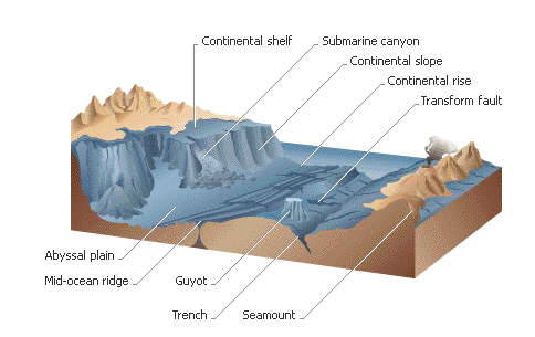
- The ocean contains a diverse range of landscapes that closely resemble those found on land, including mountains, basins, plateaus, ridges, canyons and trenches. These features on the ocean floor are known as submarine relief.
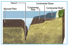
- The division of the ocean floor can be categorized into four main divisions i.e., the continental shelf, the continental slope, the abyssal plains, and the ocean depths.
Continental Margin
- The continental margin comprises the continental shelf, slope, and rise. The continental shelf is the submerged top of a continent that has been shaped by the ocean, except where mountains occur at the edge of the continent.
Continental Shelf
- It is a shallow water area which surrounds the main continental land mass. Geologically, it is a part of the continent which is submerged under the oceanic waters. It is a shallow area near the coast which is usually 100 fathoms deep.
- The continental shelf slopes gently towards the ocean at an average rate of 20 meters per km with angle of slope varying from 1° to 3°.
- Continental shelves are narrow submerged landforms which are very close and parallel to the coast.
- For instance: Off the west coast of South America where the Andes Mountains are very close and parallel to the coast, the shelf is only a few hundred meters wide.
- In contrast, the eastern coast of South America has very wide shelves which measure over hundreds of km.
- On the average, continental shelf is about 70 km wide. On much of the Pacific Coast, it is relatively narrow, only a few tens of km across.
- The widest shelves occur in the Arctic Ocean. Abroad continental shelf is the sculptured build-up of sediment shed by a continent.
| Shelf Break – Shelf Break (also called Submerged Offshore edge) of shallow continental shelf is the point where sea-floor transitions to continental slope. |
Continental Slopes
- It starts after the Shelf-Break. It is characterized by an increase in the angle of slope which ranges from 5° to 60°.
- It inhabits only 8.5 percent of the total area of the ocean basins but it varies from one ocean to the other.
- It occupies 12.4 percent of the Atlantic Ocean basin, 7 percent of the Pacific Ocean basin and 6.5 percent of the Indian Ocean.
- It is usually occupied with sediments and gravels and no significant mineral deposits are found.
- Physical features such as submarine canyons are associated with the continental slope.
| Submarine Canyon – Submarine Canyons are long, narrow and very deep valleys or trenches which are located on the continental shelves and slopes with vertical walls. – These physical features resemble the continental canyons and are called Submarine canyons because of their location beneath the water. – These physical features start from continental shelf break and extend up to continental slopes. – Unlike deep-sea trenches, which are found mostly on plate boundaries, undersea canyons are found along the slopes of most continental margins. 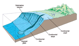 |
Continental Rise
- It is a main depositional system in oceans made up of thick sequences of continental material that accumulate between the continental slope and the abyssal plain.
- The thick sediments that form continental rise accumulate as a result of three sedimentary processes: mass wasting, the deposition from contour currents, and the vertical settling of clastic and biogenic particles.
Abyssal Plains or Deep Sea Plain
- They are extensive plains that lie between the mid-oceanic ridges and the continental margins.
- These are the areas where the continental sediments that move beyond the margins get deposited.
- These areas are the smoothest and flattest surfaces on Earth which are covered with sediments such as silt and mud.
- These plains are extensively found in the Atlantic Ocean and unusual in the Pacific Ocean.
Ocean Deeps or Trenches
- Ocean deeps represent depressions and trenches on the ocean floors which are the deepest zones of the ocean basins. These are generally located parallel to the coasts facing mountains and along the islands, on the subduction zones of oceanic plates.
Mid Ocean Ridges
- It happens along divergent plate boundaries, where the new ocean floor is shaped as the Earth’s tectonic plates spread apart. Molten rock is outpoured to the seafloor due to movement of plates separately from each other.
- The rate at which spreading occurs impacts the formation of ridges. Slower spreading rates lead to steeper and more irregular topography, whereas faster spreading rates result in wider profiles with gentler slopes.
- Two mid-ocean ridges within the global system are the Mid-Atlantic Ridge and the East Pacific Rise.
Minor Relief Features
| Abyssal Hills | – Abyssal hills are small, topographically well-defined submarine hills which may rise from several metres to several hundred metres above the abyssal plain. – These hills are located 3,000 to 6,000 metres (10,000 to 20,000 feet) deep below the water. – They are formed either by volcanism or block faulting. Abyssal hills are generally covered with marine sediments and are identical in composition and origin to the extrusive basaltic prominences on the upper flanks of mid-ocean ridges and rises. – It underlies most of the ocean floor but are locally buried by accumulations of abyssal sediment. – For instance, In the Atlantic Ocean, long abyssal hill provinces parallel both flanks of the Mid-Atlantic Ridge along most of its length. – Between 80 – 85 percent of the Pacific abyssal floor is engaged by abyssal hills. Abyssal hills are also known as Sea Knolls. 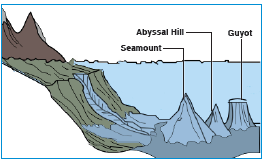 |
| Sea Mount | – Seamount, a large submarine volcanic mountain rising at least 1,000 m (3,300 feet) above the surrounding deep-sea floor but they cannot reach above the sea surface. – These are isolated steep submarine volcanic hills which are 2-100 m wide and less than 1000 m high. – The sides of the sea mounts have steep slopes of 20º to 25º. Some of the peaks of the sea mounts emerge out of water and become islands. |
| Guyot | – This is a submarine volcanic mountain that stands alone, with a flat summit more than 200 metres below sea level. – These mountains have flat tops that are larger than 10 km in diameter. These particular hills are often referred to as table mounts. |
| Atoll | – An atoll is a ring-shaped coral reef, a series of islets or islands. – It is surrounded by a body of water known as a lagoon. Often, lagoons and atolls protect a central island. – Channels between islets connect a lagoon to the open sea or ocean. Atolls form around submerged volcanoes called seamounts. |