The SouthWest Monsoon in India is a major seasonal wind system that brings substantial rainfall to the Indian subcontinent from June to September. Its significance lies in its critical role in replenishing water resources and supporting agriculture across the region. This article aims to study in detail the characteristics, impacts, and mechanisms of the Southwest Monsoon, along with the various theories that explain its behaviour.
About Indian Monsoon
- The Indian Monsoon is a critical climatic phenomenon characterised by seasonal wind shifts that bring heavy rains to the Indian subcontinent.
- The Southwest Monsoon typically begins in June, bringing moisture-laden winds from the Indian Ocean, and continues until September.
- The Northeast Monsoon, occurring from October to December, affects southeastern India.
Read our detailed article on the Monsoon in India.
About SouthWest Monsoon Season
- The South West Monsoon is a major seasonal wind system that brings substantial rainfall to the Indian subcontinent.
- It typically begins in June and lasts until September, driven by moisture-laden winds from the Indian Ocean.
- The monsoon is characterised by heavy rains and is crucial for agriculture and water resources in India.
Features of SouthWest Monsoon
These winds generally strike the Indian coast in the first week of June. However, their arrival and departure may be before time or even delayed.
- There may be dry spells between rainy periods, leading to crop failure.
- At times, these winds may skip over certain regions without any apparent cause.
- The amount and timing of rainfall and the intervals of wet and dry spells vary yearly, a phenomenon known as the vagaries of the monsoons.
- The spatial distribution of rainfall is uneven: some regions may experience heavy rains, while others receive meagre or scanty rainfall.
- Typically, these winds begin retreating by the end of September, but their departure may sometimes be delayed until October.
Theories for Prediction of Indian Monsoon
There are several theories for the prediction of the Indian Monsoon:
- The Thermal Theory,
- The Equatorial Westerly Theory,
- The Jet Stream Theory, and
- The El- Nino Theory.
All these theories have been discussed in detail in the following section.
The Thermal Theory
- According to the thermal theory, temperature is the main reason for the origin of the monsoons.
- In summer, sun rays cause greater low pressure, which results in the absence of north-east trade wind.
- According to Ferrell’s rules, these winds turn towards their right (northeast) when they come in the northern hemisphere and blow on the whole Indian peninsula.
- These winds are full of moisture. They bring rainfall over the Indian peninsula by dividing it into two branches.
- Heavy rainfall occurs on the western slope of the Western Ghats by the Arabian Sea branch, and Andaman and Nicobar Islands and northeast India by the Bay of Bengal branch.
- The Bay of Bengal branch moves towards the low-pressure areas of northwest India.
- The amount of rainfall keeps becoming less because of a shortage of water vapour when it moves from east to west.
- In winter, the northeast trade wind once again begins to blow.
- They bring the northeast monsoon and cause rainfall on the coast of Tamil Nadu after getting water vapour from the Bay of Bengal.
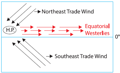
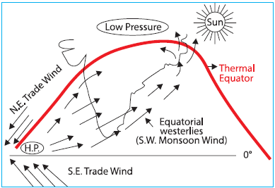
The Equatorial Westerly Theory
- The Equatorial Westerly Theory was propounded by Flohn.
- According to him, the equatorial westerly is the south west monsoon.
- It originated because of inter-tropical convergence.
- He also considered the thermal effect to be the main reason for the origin of monsoons.
- In the summer, the ITCZ happen in the north of the equator because of the northern movement of the thermal equator.
- The equatorial westerly now begins blowing toward the low pressure created on the Indian Peninsula; it is the SouthWest Monsoon.
- The ITCZ is known as the Monsoon Trough.
- In winter, the area of low pressure changes into high pressure because of the winter solstice and northeast trade winds once again become active.
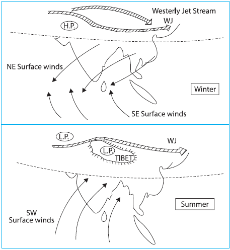
The Jet Stream Theory
- The Jet Stream theory was propounded by Yest. The jet stream is a very fast-blowing current system in the upper atmosphere (9 to 18 km), and its speed is maximum in the middle part (340 km/hr).
- This system works as a cover over Earth, which affects the weather in the lower atmosphere.
- The south east monsoon in India is related to the tropical easterly jet stream, which blows between 80 N and 350 N latitude.
- The northeast (winter monsoon) is associated with the subtropical westerly jet stream, which blows between 20° and 30° latitude in both hemispheres.
- In the winter, the subtropical westerly jet stream blows from west to east over West and Middle Asia.
- The Tibetan plateau is divided into two parts, creating hurdles in its way. One branch began to blow parallel to the plateau from the north, and another moved towards the east in the south of the Himalayas.
- The mean position of these branches was roughly between 25°N latitude in February.
- The western disturbances that enter the Indian subcontinent in winter are brought by the westerly jet stream.
- This disturbance generally occurs before westerly jet streams.
- The westerly jet stream is a column of cold wind that pushes downwind to the surface, creating high pressure on the surface.
- The dry wind from this high-pressure area (the northwest part of India) begins blowing towards a low-pressure area (the Bay of Bengal).
- This wind brings cold winds in winter to Uttar Pradesh and Bihar.
- After reaching the Bay of Bengal, this wind, following Ferrell’s rules, becomes a northeast monsoon.
- When this monsoon wind reaches the coast of Tamil Nadu, it causes rainfall with humidity received from the Bay of Bengal.
- The summer westerly jet stream does not blow over the Indian subcontinent. It transits towards the north of the Tibetan plateau.
- At this time, the tropical easterly jet stream blows into India’s upper atmosphere (the upper parts of the troposphere).
- The Tibetan plateau and central Asia becoming too hot is considered a reason for its origin.
- The clockwise cyclic circulation in the middle of the troposphere begins with the winds rising from the plateau of Tibet after becoming hot.
- This going upward air divides itself into two separate streams near the tropopause.
- One of these blows is in the form of easterly jet streams toward the equator, and the other blow is in the form of westerly jet streams toward the pole.
- It is to be noted that a westerly jet stream keeps blowing in central Asia in summer.
- The easterly jet streams begin to settle in the Arabian Sea by blowing towards the southwest direction in the upper atmosphere.
- It creates a very high-pressure belt over there.
- Inversely when this hot jet stream blows over the Indian subcontinent, it pulls up the surface air and creates a very low pressure.
- To fill this low pressure, winds from a high-pressure area of the Arabian Sea begin to blow towards the northeast.
- This is known as the SouthWest Monsoon.
| Note: However, studies show this easterly jet stream is only seasonal. When it blows for an extended period over a large area in India, it causes floods, and when it weakens, it causes droughts. This theory does not explain why easterly jet streams are so much indefinite. |
The El-Nino Theory
- El-Nino is characterised by subsurface warm ocean currents flowing north to south along the Peruvian coast.
- American scientist Gilbert Walker initially studied it, and observed that the warm water of El-Nino increases the temperature of southern equatorial warm ocean currents.
- This current flows east to west in the middle Pacific Ocean, warming the region and causing very low atmospheric pressure there.
- When this low pressure extends to the eastern central parts of the Indian Ocean, it alters the direction of the Indian monsoon.
- The low pressure over the Indian subcontinent becomes comparatively weaker than the low pressure in the Indian Ocean.
- Consequently, winds from high-pressure areas of the Arabian Sea blow towards the southeastern Indian Ocean, leading to drought in the Indian subcontinent.
- Conversely, if the effects of the El-Nino water current remain confined to the middle Pacific, the southwest monsoon winds remain undisturbed, resulting in sufficient rainfall in India.
- However, the effects of El Nino alone cannot fully explain drought conditions in India, indicating the need for further research in this area.
Conditions during South West Monsoon
The southwest monsoon in India typically occurs from June to September and is characterised by several conditions:
Temperature
- Sudden Onset and Temperature Fall – The arrival of the southwest monsoons leads to a significant drop in temperature (3°C to 6°C).
- This temperature change varies throughout the rainy season.
- Temperature Variability – Temperature rises in September with the cessation of the southwest monsoons.
- Breaks in the monsoons also cause temporary increases in temperature.
- The diurnal temperature range is small due to cloud cover and rainfall.
- Regional Temperature Patterns- The highest temperatures (38°C to 40°C) are experienced west of the Aravalis due to a lack of clouds and hot continental air masses.
- The Western Ghats have lower temperatures due to heavy rainfall, while Tamil Nadu and adjoining Andhra Pradesh have temperatures above 30°C due to minimal rainfall.
Pressure and Winds
- Low Pressure Conditions – Due to high temperatures, Low pressure prevails over northwest India, with the ITCZ (monsoon trough) lying along the Ganga plain.
- Its location shifts depending on weather conditions.
- Wind Patterns – Winds blow from southwest to northeast due to the pressure gradient between north and south.
- In the Indo-Gangetic plain, winds change direction from east to west.
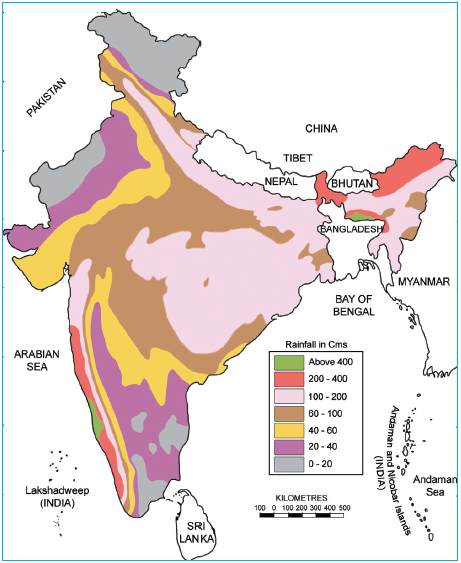
Rainfall
- Rainfall Distribution: The southwest monsoon accounts for three-fourths of India’s total annual rainfall.
- The average rainfall over the plains during this season is about 87%.
- Advance and Timing: The south west monsoon advances quickly with thunder, lightning, and heavy downpours.
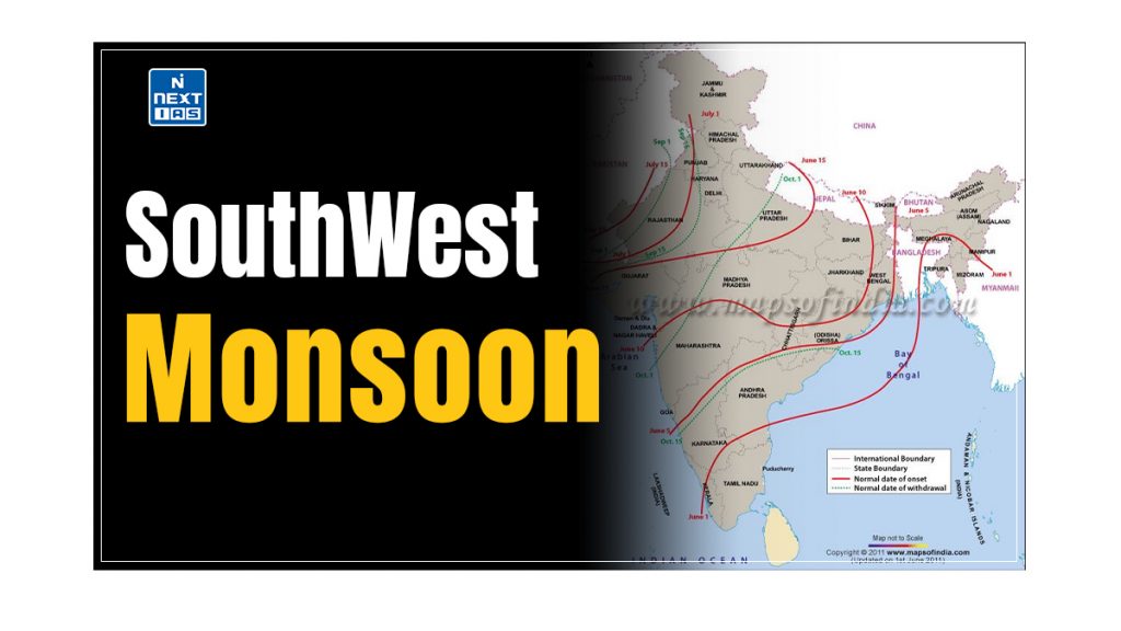
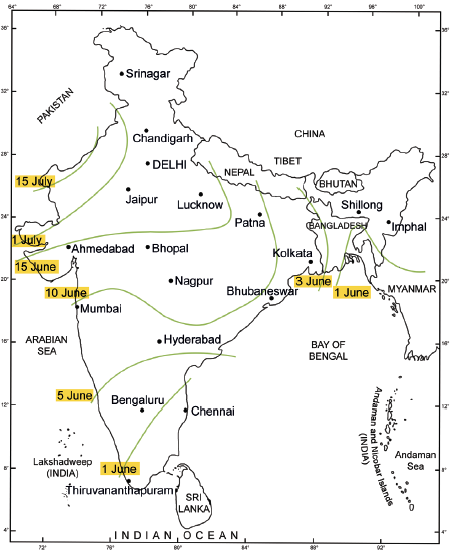
- The normal arrival date is 20th May in the Andaman and Nicobar Islands and 1st June in Kerala.
- Delays in the south west monsoon can reduce its duration, with rainfall decreasing from south to north.
| Variability of Rainfall – Rainfall variability is computed using the coefficient of variation (C.V.). – Areas with less than 25% variability receive annual rainfall over 100 cm, while areas with more than 50% have annual rainfall less than 50 cm. – Regions with 25-50% variability receive 50-100 cm of annual rainfall. |
Mechanism of South West Monsoon
- The Southwest Monsoon begins with the inflow of Southwest monsoons, which generally strike the coast of Kerala in the first week of June and cover most of India by mid-July.
- This weather pattern continues until September. The arrival of these warm, moisture-laden winds brings a significant change in weather conditions, causing sudden rains that reduce temperatures by 5°C to 10°C.
- This sudden onset of rain is called a break of monsoons or a burst of monsoons.
- Depending on the pressure conditions over the northern plains and the Indian Ocean, the arrival of these winds may be delayed by a week or two.
- The peninsular shape of India divides these Southwest monsoons into two branches:
- The Arabian Sea branch and
- The Bay of Bengal branch.
Monsoon Winds of Arabian Sea
The Southwest monsoon winds originating over the Arabian Sea further split into three branches:
First Branch
- The first branch of the Arabian Sea monsoon is blocked by the Western Ghats.
- As these winds ascend the slopes of the Western Ghats, at elevations of 900-1200 meters, they cool down.
- Consequently, the windward side of the Sahyadris and the Western Coastal Plain receives very heavy rainfall, ranging from 250 cm to 400 cm.
- After crossing the Western Ghats, these winds descend and warm up, reducing humidity.
- This leads to little rainfall east of the Western Ghats, creating a rain-shadow area.
Second Branch
- The second branch of the Arabian Sea Monsoon impacts the coast north of Mumbai.
- Travelling along the Narmada and Tapi river valleys, these winds bring rainfall to large areas of central India.
- The Chotanagpur plateau receives 15 cm of rainfall from this branch.
- Subsequently, these winds enter the Ganga plains and mingle with the Bay of Bengal branch.
Third Branch
- A third branch of this monsoon wind hits the Saurashtra Peninsula and Kutch, then moves over west Rajasthan and along the Aravallis, resulting in only scanty rainfall.
- In Punjab and Haryana, it merges with the Bay of Bengal branch.
- Together, these branches bring rainfall to the western Himalayas.
Monsoon Winds of Bay of Bengal
- The Bay of Bengal branch strikes the coast of Myanmar and part of southeast Bangladesh. However, the Arakan Hills along the coast of Myanmar deflect a significant portion of this branch towards the Indian subcontinent.
- Consequently, the South West Monsoon enters West Bengal and Bangladesh from the south and southeast rather than the south-westerly direction.
- From here, this branch splits into two due to the influence of the Himalayas and the thermal low in northwest India.
- One branch travels westward along the Ganga plains, extending to the Punjab plains.
- The other branch moves up the Brahmaputra valley in the north and northeast, resulting in widespread rainfall.
- A sub-branch impacts the Garo and Khasi Hills of Meghalaya.
- Mawsynram, situated on the crest of the Khasi Hills, records the highest average annual rainfall in the world.
| Note: It is essential to understand why the Tamil Nadu coast remains dry during this season. Two factors are responsible: – The Tamil Nadu coast is parallel to the Bay of Bengal branch of the SouthWest monsoon. – It lies in the rainshadow area of the Arabian Sea branch of the Southwest Monsoon. |
Conclusion
The South West Monsoon is a complex and critical climatic system that profoundly impacts the subcontinent’s environment and economy. The South West Monsoon, with its intricate wind patterns and significant rainfall, is crucial for replenishing water sources and supporting agriculture. The variability and intricacies of monsoon behaviour, influenced by various climatic theories and regional factors, underscore the importance of ongoing research and monitoring. As we continue to study and understand these patterns, we can better prepare for and adapt to the challenges of monsoon variability and its effects on the Indian subcontinent.
Difference between South West Monsoon and North East Monsoon
| Aspects | South-West Monsoon | North-East Monsoon |
|---|---|---|
| Season | June to September | October to December |
| Wind Direction | Southwest to Northeast (SW -> NE) | Northeast to Southwest (NE -> SW) |
| Source of Moisture | Indian Ocean | Bay of Bengal |
| Regions Affected | Most of India | South Eastern Coast of India, esp. Andhra Pradesh and Tamil Nadu |
| Type of Rainfall | Heavy Rainfall | Moderate Rainfall |
Frequently Asked Questions (FAQs)
What is the South West Monsoon?
The South West Monsoon is a seasonal wind pattern that brings heavy rainfall to the Indian subcontinent, typically from June to September. It occurs due to the differential heating of land and sea, where the Indian landmass heats up more than the surrounding ocean, causing moist air from the Indian Ocean to flow towards the land.