
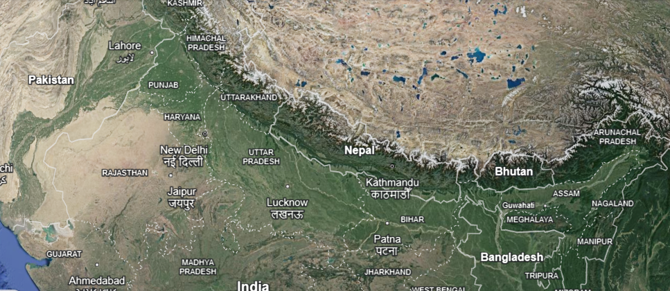
Seated between the Indo-Gangetic Plains and the high Tibetan Plateau, the Himalayas constitute one of the most majestic mountain ranges in the world. Much more than just a geographical entity, the Himalayas gain significance for their environmental, cultural, and geopolitical implications. This article of NEXT IAS aims to study in detail the Himalayas, including their formation, divisions, important ranges, significance, and other related aspects.
About Himalayas
The Himalayas are young fold mountains formed by the convergence of two tectonic plates. They constitute one of the 5 physiographic divisions of India. Along with acting as a grand barrier guarding India’s frontiers, they also act as a dividing range between the Tibetan Plateau in the north and India in the south.
Formation of Himalayas
The Himalayas were formed several million years ago as a result of the convergence of the Indo-Australian Tectonic Plate with the Eurasian (Asian) Tectonic Plate. The series of events that led to their genesis and evolution are listed chronologically below:
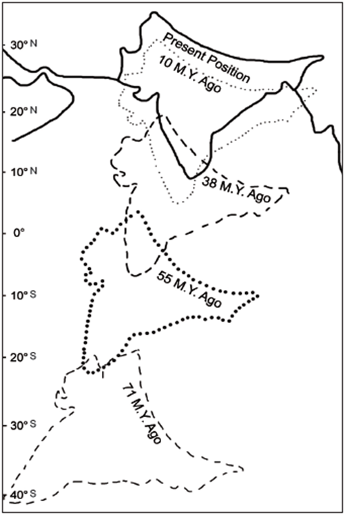
- Existence of Pangea and Panthalassa: Around 250 million years ago, there existed a supercontinent called Pangea (a giant formation of land under which all the continents of the world were attached together as a monolithic structure). This Pangea was surrounded by a massive water body called Panthalassa.
- Breaking of Pangea: Around 150 million years ago, the supercontinent Pangea began to break into different parts. First of all, it broke into two parts:
- Laurasia or Angaraland: The northern part of the Pangea was called Angaraland or Laurasia.
- It consisted of landmasses that contained present-day North America, Europe, and Asia.
- Gondwanaland: The southern part of the Pangea was called Gondwanaland.
- It consisted of present-day South America, Africa, South India, Australia, and Antarctica.
- Laurasia or Angaraland: The northern part of the Pangea was called Angaraland or Laurasia.
- Formation of Tethys Sea: Due to the breaking down of Pangea, a long narrow sea was created between Angaraland and Gondwanaland, occupying the area where the Himalayas stand today. This sea was known as the Tethys Sea.
- Deposition of Sediments: During the course of time, huge amounts of sediments were deposited in the bed of the Tethys Sea by the rivers flowing from Angaraland as well as Gondwanaland.
- Breaking Down of Gondwanaland and Angaraland: The Gondwanaland and Angaraland were further broken down into different smaller landmasses. The Indo-Australian Plate (comprising present-day Australia and the Indian Sub-continent) emanated from the Gondwanaland and the Eurasian Plate (containing present-day Europe and Northern Asia) emanated from the Angaraland.
- Convergence of Indo-Australian and Eurasian Plates: The convectional currents generated in the Mantle of the Earth made the Indo-Australian Plate drift northwards towards the Eurasian Plate. This drift continued for millions of years, leading to the convergence of the two plates across the Tethys Sea.
- Formation of Folds: As the two plates continued to approach each other, the area of the Tethys Sea began to shrink and the sediments in its seabed were slowly pushed upwards, leading to the formation of folds.
- Genesis of the Himalayas: Eventually, the Tethys Sea vanished completely and sediments rising from its seabed formed a mountain range, which is now known as the Himalayas.
- It is to be noted that the convergence of the two tectonic plates continues to date, leading to the rising of the Himalayas by about 5 mm per year even now.
Types of Himalayas
- The Himalayas, one of the youngest mountain ranges in the world, are classified into four distinct types based on their geographical and geological characteristics.
- These are the Trans-Himalayas, located to the north of the Great Himalayas, characterised by arid landscapes and high plateaus; the Greater Himalayas (Himadri), the highest and most continuous range that hosts prominent peaks like Mount Everest and Kanchenjunga; the Lesser Himalayas (Himachal), marked by rugged terrains and famous hill stations like Shimla and Darjeeling; and the Shivalik Hills, the outermost and youngest range featuring low-altitude foothills.
- Together, these ranges form a natural barrier and are vital for India’s climate, biodiversity, and water resources.
Longitudinal Division of Himalayas
On the basis of the latitudinal extent, the Himalayas can be divided into three divisions:
- Trans-Himalayas.
- The Himalayan Mountain Ranges.
- The Eastern Hills or Purvanchal.
The Trans-Himalayas
- It is the name denoted to the Himalayan Ranges which are north of the Great Himalayan Range.
- They stretch in an east-west direction for a distance of about 1,000 km.
- Their average elevation is approximately 3000 meters above mean sea level.
- The prominent ranges that comprise the Trans-Himalayas include – The Karakoram Range, the Ladakh Range, and the Zaskar Range.
Karakoram Range
- The Karakoram Range is the northernmost range of the Trans-Himalayan in India.
- It forms India’s boundary with Afghanistan and China.
- The average width of this range is 110-130 km.
- It is home to some of the highest peaks and the largest glaciers in the world.
- K2, also known as Mount Godwin-Austen, lies in this range.
- It is approximately 8611m high and is the second-highest peak in the world.
- Siachen Glacier and Remo Glacier are some of the prominent glaciers lying in this range.
- K2, also known as Mount Godwin-Austen, lies in this range.
Ladakh Range
- It is considered the southeastern extension of the Karakoram Range.
- From the mouth of the Shyok River in north Kashmir, it extends in the southeast direction towards the Indo-Tibetan borders.
- The Deosai Mountains, situated towards the southwest of the Indus River in Pakistan-Occupied Kashmir (POK), are occasionally considered part of the Ladakh range.
- The Kailash Range in western Tibet is also considered a westward extension of the Ladakh Range.
Zaskar Range
- It runs more or less parallel to the Great Himalayan Range.
- This range extends in the southeast direction from the Suru River to the upper Karnali River.
- Kamet Peak (25,446 feet) is the highest peak in this range.
The Himalayan Ranges
- Alternative Names: The Himalayan Ranges are known by various other names such as Himadri, Himavan, etc.
- Composition: The Himalayan Range is the youngest mountain range in the world and consists mostly of uplifted sedimentary and metamorphic rocks.
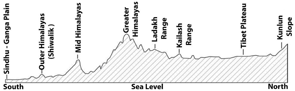
- Boundaries: They are bordered on the northwest by the Karakoram and Hindu Kush ranges, on the north by the Tibetan Plateau, and on the south by Indo-Gangetic Plains.
- The southern boundary of the Himalayas is well-defined by the foothills but the northern boundary is rather obscure and merges with the edge of the Tibet Plateau.
- Extent: The range of the main Himalayas stretches for a distance of over 2,400 km from the Indus Gorge in the west to the Brahmaputra Gorge in the east.
- Width: The Himalayan Mountain Ranges are wider on the western side compared to the eastern side.
- Elevation: The average elevation of the Himalayan Range is approximately 6,100 m.
- While the elevation of the Western Himalayas witnesses a gradual change, there is a comparatively rapid change in elevation in the Eastern Himalayas.
- Sub-Divisions: The Himalayan Ranges are further subdivided into Greater Himalayas, Inner or Middle Himalayas, and Shiwalik.
The Greater Himalayas
- They are also known as the Himadri, the Inner Himalayas, or the Central Himalayas.
- These mountains are composed of Archaean rocks like granite, gneisses, and the ancient schist.
- The orientation of the Greater Himalayas changes in different regions as explained below:
- They extend towards the southeast across the regions of northern Pakistan, northern India, and Nepal
- Thereafter, they curve eastwards across the regions of Sikkim and Bhutan.
- Finally, they turn towards the northeast across the region of northern Arunachal Pradesh.
- They comprise several of the world’s highest peaks.
- Some of the prominent peaks in the Greater Himalayas (from west to east) include – Nanga Parbat, Mount Everest, Kanchenjunga, and Namcha Barwa.
- The orientation of slopes in this range is steep towards the north and gentle towards the south.
The Inner or Middle Himalayas
- They are also called Lesser Himalayas or Lower Himalayas.
- Their mean elevation is about 3,500 to 5,000 meters and their average width is about 60 to 80 km.
- Prominent ranges comprising this sub-division of the Himalayas include – Nag Tibba, Mahabharat Range, Dhauladhar, the Pir Panjal, and the Mussoorie Range.
- Various important rivers such as Jhelum and Chenab pass through this range.
- The famous Valley of Kashmir lies between Pir Panjal and Zanskar range.
- The Jhelum River cuts through the Kashmir valley.
- They are also home to some famous hill resorts like Shimla, Chail, Ranikhet, Chakrata, Nainital, Almora, etc.
- The Middle Himalayas are also famous for the formation of Karewas, which refer to fluvioglacial deposits between the Greater Himalayas and the Middle Himalayas (Pir Panjal).
The Shiwalik or Outer Himalayas
- The Shiwalik Hills are the southernmost range of the Himalayas which lie between the Middle Himalayas in the north and the Indo-Gangetic Plains in the south.
- They rise abruptly from the plain of the Indus and Ganges rivers in the south and parallel the main range of the Himalayas in the north.
- They are separated from the main Himalayan Range by valleys.
- The portion of the Shiwalik lying in the region of Nepal is called the Churia Range.
- The Shiwaliks are wider on the western side compared to the eastern side.
- Formation of Doons and Duars is the peculiar feature of the Shiwaliks.
- The upliftments of the Shiwaliks stopped the flow of many rivers, resulting in the formation of temporary lakes. The sediments being carried by these rivers were deposited at the bottom of these lakes. Over a period of time, the rivers could cut through the Shiwalik. As a result, water drained away from these lakes, and the sediments in the form of fertile alluvial soils were left behind.
- It is these fertile alluvial soils, which are known as Doons in the west and Duars in the eastern part of India.
- They are important for the cultivation of tea.
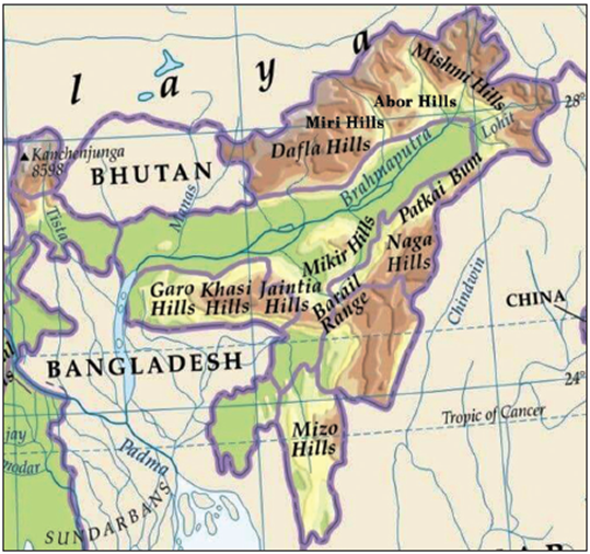
The Eastern Hills or the Purvanchal
- Towards the region of Dihang Gorge, the Himalayas take a rapid southward turn because of Syntaxial Bend and form a series of relatively low hills. Collectively, these hills are also called Purvanchal as they are located in the eastern part of India.
- They extend from Arunachal Pradesh in the north to Mizoram in the south.
- These hills constitute India’s border with Myanmar.
- Prominent ranges comprising the Purvanchal include the following:
Patkai Bum
They are the northernmost range of Purvanchal, lying along the boundary between Arunachal Pradesh and Myanmar.
Naga Hills
They lie to the south of Patkai Bum. They, along with Patkai Bum, form the watershed between India and Myanmar.
Manipur Hills
They are situated to the south of Naga Hills. The Barail Range splits the Naga Hills from the Manipur Hills.
Mizo Hills or Lushai Hills
They lie to the south of Manipur Hills.
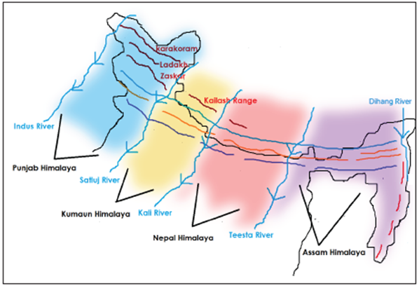
Regional Division of Himalayas
Based on the longitudinal extent, the Himalayas have been divided into 4 regional divisions – Punjab Himalayas, Kumaon Himalayas, Nepal Himalayas, and Assam Himalayas.
Punjab Himalayas
- It lies between the Indus River in the west and the Sutlej River in the east.
- The majority of this region lies in the state of Jammu and Kashmir and Himachal Pradesh. Hence, they are also known as Kashmir and Himachal Himalayas.
- Nearly, all the ranges such as Karakoram, Pir Panjal, Ladakh, Zanskar and Dhauladhar are prominent in this section.
- It is dominated by high snow-covered mountains, deep gorges, and high mountain passes.
Kumaon Himalayas
- It lies between the Satluj River in the west and the Kali River in the east.
- It is also known as Garhwal Himalayas in the west.
- As compared to the Kashmir Himalayas, this region is more loftier.
- Prominent peaks lying in this region include – Nanda Devi, Trisul, Kedarnath, Dunagiri, Kamet, Badrinath, etc.
- This region is home to some of the major hill stations such as Nainital, Ranikhet, and Almora.
Nepal Himalayas
- It stretches from the Kali River in the west to the Tista River in the east.
- A majority of this section lies in Nepal, therefore it is called Nepal Himalayas.
- This section is dominated by some of the tallest peaks in the world, including Mount Everest, Kanchenjunga, Dhaulagiri, etc.
- The famous Valley of Kathmandu is located in this region.
Assam Himalayas
- It is a sector of the Himalayas that lies between the Tista River in the west and the Brahmaputra River in the east.
- In India, it covers the states such as Assam and Arunachal Pradesh.
- This sector is much lower in elevation when compared to the Nepal Himalayas.
- The Himalayas make a sudden turn towards the south in the region of Arunachal Pradesh. Hence, ranges in the Assam Himalayas region are arranged in the north-south direction.
- Prominent peaks in this region include – Namcha Barwa, Gyala Peri, Kengto, and Nyegyi Kangsang.
- Namcha Barwa is the highest peak in this region.
Sntaxial Bends of Himalayas
At its western and eastern extremities, the east-west trend of Himalayan Ranges is suddenly terminated and the continuous range takes a sharp turn southwards. These sharp bends are called Syntaxial Bends of the Himalayas.
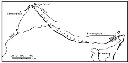
Western Syntaxial Bend
It occurs at the western extremity of the Himalayas near the Nanga Parbat where the River Indus cut the deep gorge.
Eastern Syntaxial Bend
It occurs at the eastern extremity of the Himalayas near the Namcha Barwa (Arunachal Pradesh), where the mountain ranges turn southwards after crossing the Brahmaputra.
Comparison of Western and Eastern Himalayas
| Parameters | Western Himalayas | Eastern Himalayas |
|---|---|---|
| Extent | The Western Himalayan ranges lie between the Indus river in the west and the Kali river (Nepal) in the east. | The Eastern Himalayan range extends from the Tista River in the west to the easternmost extent of the Himalayan Ranges. |
| Gradient | In the portion of western Himalayan ranges, height is attained in gradual successions as the mountains from the plains rise in a series of stages. Thus, the higher mountain ranges are far away from the plains. | The Eastern Himalayan ranges rise abruptly from the plains, thus peaks are not very far away from the plains such as Kanchenjunga. |
| Precipitation | The amount of rainfall in the Western Himalayan ranges is less and is 1/4th of that of the Eastern Himalayan ranges. | The Eastern Himalayan ranges face high rainfalls and they are covered with dense forests. |
| Vegetation | The dominant vegetation in the Western Himalayas includes Coniferous Forests and Alpine Vegetation. | The dominant vegetation in the Eastern Himalayas includes Evergreen Forests (along the foothills), Temperate Broadleaf Forests, and Alpine Forests. |
| Biodiversity | In terms of biodiversity, the Western Himalayas lag behind the Eastern Himalayas. | Eastern Himalayan ranges have a high level of biodiversity due to the presence of Tropical Evergreen Forests. In fact, they are one of the Biodiversity Hotspots in India. |
| Read our detailed article on the Important Peaks of the Himalayas |
Significance of the Himalayas
- Climatic Influence: These ranges significantly affect the climate of India.
- Owing to their high altitude, length, and direction, they effectively interrupt the summer monsoonal winds coming from the Bay of Bengal and the Arabian Sea and trigger precipitation in the form of rain or snow.
- They also prevent cold winter winds from the Siberian region from entering India.
- Security: These ranges have been protecting India from outside forces and intruders since ancient times thus serving as a defense barrier for India.
- Perennial Source of Water: They are the source of the majority of large rivers of India, which form the footing of life in the entire north India.
- Forest Wealth: They host the base of a rich forest that provides fuel wood and a huge diversity of raw materials for forest-based industries.
- Agriculture: Though the Himalayan ranges do not provide extensive plains for agricultural activities, some of the slopes have been terraced for cultivation.
- Minerals: The Himalayan region is a source of many valuable minerals such as Copper, Lead, Zinc, Nickel, Cobalt, Antimony, Tungsten, Gold, Silver, Limestone, Semi-Precious and Precious Stones, Gypsum, and Magnetite.
- Hydroelectricity: Due to the presence of rugged topography and fast-flowing rivers, these mountain ranges hold a huge potential for Hydroelectricity.
Much more than just a geographical feature, the Himalayas carry multifarious significance for the Indian subcontinent. Of late, they have been facing some significant ecological challenges arising out of factors such as climate change, deforestation, pollution, and unregulated tourism. Ensuring the sustainability of the Himalayas is not just crucial for the subcontinent but for the ecological health of the entire planet. Sustainable development is the way forward.
Frequently Asked Questions (FAQs)
Where is Himalaya located in India?
The Himalayas stretch across the northern border of India, covering states like Jammu & Kashmir, Himachal Pradesh, Uttarakhand, Sikkim, Arunachal Pradesh, and parts of West Bengal and Assam.
What is Himalayas?
The Himalayas are a vast mountain range in South Asia, known for their towering peaks, including Mount Everest, and their significance in shaping the region’s climate and biodiversity.
How were the Himalayas formed?
The Himalayas were formed due to the collision of the Indian Plate with the Eurasian Plate about 50 million years ago, leading to the uplifting of the Earth’s crust.
What other name is given to the mountains of the Himalayas?
The Himalayas are also known as the “Abode of Snow” (derived from the Sanskrit word Himālaya).
Himalayas are divided into how many ranges?
The Himalayas are divided into three main ranges: the Greater Himalayas (Himadri), the Lesser Himalayas (Himachal), and the Shivalik Hills. Some classifications also include the Trans-Himalayas.