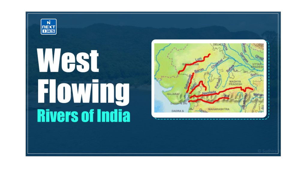
The West-flowing Rivers of Peninsular India flow towards the Arabian Sea, traversing through unique geological formations like rift valleys. These rivers play a crucial role in the region’s hydrology, supporting agriculture and contributing to the local economy through fishing and hydroelectric power generation. This article aims to study in detail the west-flowing rivers, their characteristics, courses, tributaries, and the various projects developed along them.
About West Flowing Rivers of India
- India is a geographical paradise with many rivers flowing across the country.
- While most of the country’s rivers flow eastward, joining the Bay of Bengal, a few rivers defy the odds and flow westward.
- These west-flowing rivers ultimately end up in the Arabian Sea.
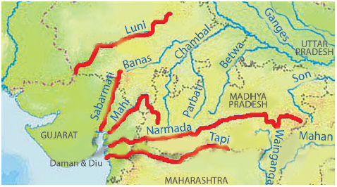
- The two major west-flowing rivers are the Narmada and the Tapi.
- This exceptional behaviour is because these rivers didn’t form valleys; instead, they flow through faults (linear rift, rift valley, trough) created by the bending of the northern peninsula during the formation process of the Himalayas.
- These faults run parallel to the Vindhyas and the Satpuras.
- These rivers traverse through rift valleys, a geological formation resulting from the bending of the northern peninsula during the formation of the Himalayas.
Characteristics of West-Flowing Rivers of India
- The Peninsular Rivers which fall into the Arabian Sea do not form deltas but only estuaries.
- This is because the west-flowing rivers, especially the Narmada and the Tapi, flow through hard rocks and hence do not carry much silt.
- Moreover, the tributaries of these rivers are very small, and they don’t contribute any silt.
- Hence, these rivers cannot form distributaries or deltas before they enter the sea.
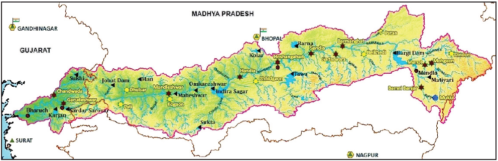
Narmada River
- Narmada is the largest west-flowing river of the Peninsular India.
- The Narmada River flows westward through a rift valley situated between the Vindhyan Range to the north and the Satpura Range to the south.
- Originating from the Maikala range near Amarkantak in Madhya Pradesh, the Narmada basin spans across the states of Madhya Pradesh, Gujarat, Maharashtra, and Chhattisgarh.
- It is bounded by the Vindhyas on the north, the Maikala range on the east, the Satpuras on the south, and the Arabian Sea on the west.
- The hilly regions are in the upper part of the basin, whereas lower-middle reaches are broad and fertile areas well suited for cultivation.
- Jabalpur is the only crucial urban centre in the basin.
- The river slopes down near Jabalpur, where it cascades (a small waterfall, especially one in a series) 15 m into a gorge to form the Dhuan Dhar (Cloud of Mist) falls.
- Since the gorge is composed of marble, it is popularly known as the Marble Rocks.
- Near Maheshwar, the river again descends from another small 8-m-high fall, the Sahasradhara Falls.
- There are several islands in the estuary of the Narmada, of which Aliabet is the largest.
- The Narmada is navigable up to 112 km from its mouth.
Tributaries of Narmada River
The left bank and right bank tributaries of the Narmada River are:
Right Bank Tributaries of Narmada River
The right bank tributaries of the Narmada River are:
- The Barna River,
- The Hiran River,
- The Tendoni River,
- The Choral River,
- The Kolar River,
- The Man River,
- The Uri River,
- The Hatni River, and
- The Orsang River.
Left Bank Tributaries of Narmada River
The left bank tributaries of the Narmada River are:
- The Burhner River,
- The Banjar River,
- The Sher River,
- The Shakkar River,
- The Dudhi River,
- The Tawa River,
- The Ganjal river,
- The Chhota Tawa river,
- The Kaveri river,
- The Kundi River,
- The Goi River, and
- The Karjan River.
Major Hydropower Projects on Narmada River
The major Hydro Power projects in the Narmada basin are:
- The Indira Sagar Dam,
- The Sardar Sarovar Dam,
- The Omkareshwar Dam,
- The Bargi & Maheshwar Dam
Tapti River (Tapi)
- The Tapti River is Peninsular India’s second-largest west-flowing river and is known as ‘the twin’ or ‘the handmaid’ of the Narmada.
- It originates near the Multai reserve forest in Madhya Pradesh.
- It drained into the Arabian Sea through the Gulf of Cambay.
- The Tapti River, along with its tributaries flows over the plains of Vidharbha and Khandesh and a small area in Madhya Pradesh.
- The basin’s hilly region is well forested, while the plains are broad and fertile, suitable for cultivation.
- There are two well-defined physical regions in the basin: the hilly region and the plains. The hilly regions, comprising Satpura, Satmalas, Mahadeo, Ajanta, and Gawilgarh hills, are well forested.
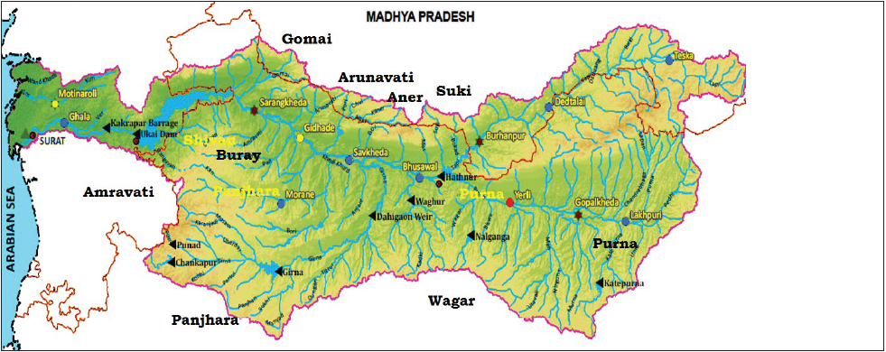
Tributaries of Tapti River
The left bank and right bank tributaries of the Tapti River are:
Right Bank Tributaries of Tapti River
The right bank tributaries of the Tapti River are:
- The Suki,
- The Gomai,
- The Arunavati and
- The Aner.
Left Bank Tributaries of Tapti River
The left bank tributaries of the Tapti River are:
- The Vaghur,
- The Amravati,
- The Buray,
- The Panjhra,
- The Bori,
- The Girna,
- The Purna,
- The Mona and
- The Sipna.
Projects on Tapti River
- The Hathnur Dam of Upper Tapi Project (Maharashtra),
- The Kakrapar weir and Ukai Dam of Ukai Project (Gujarat),
- The Girna Dam and Dahigam Weir of Girna Project (Maharashtra).
Industry in the Tapti Basin
- The important industries in the Tapti Basin are textile factories in Surat and the paper print factory in Nepanagar.
Sabarmati River
- The Sabarmati River is formed by the merging of the Sabar and Hathmati streams.
- The Sabarmati basin stretches across the states of Rajasthan and Gujarat, bounded by the Aravalli hills to the north and northeast, the Rann of Kutch to the west, and the Gulf of Khambhat to the south.
- Sabarmati originates from Aravalli hills near the village of Tepur, in the Udaipur district of Rajasthan.
- The central part of the basin is covered by agriculture accounting for 74.68% of the total area.
- Rainfall varies from a meagre few mm in Saurashtra to over 1000 mm in the southern part.
Projects on Sabarmati River
- The Sabarmati Reservoir (Dharoi),
- The Hathmati Reservoir, and
- The Meshwo Reservoir Project.
Mahi River
- The Mahi River originates from the northern slopes of Vindhyas in the Dhar district of Madhya Pradesh.
- It drains into the Arabian Sea through the Gulf of Khambhat.
- The Mahi basin extends over the states of Madhya Pradesh, Rajasthan, and Gujarat.
- The major part of the basin is covered with agricultural land, about 63.63% of the total area.
- It is one of the major inter-state west-flowing rivers of India.
Projects on Mahi River
The important Hydro Power stations are located in Mahi Basin are:
- The Mahi Bajaj Sagar Dam,
- The Kadana Dam, and
- The Wanakbori Dam (Weir).
| Note: The city of Vadodara lies in the Mahi basin. |
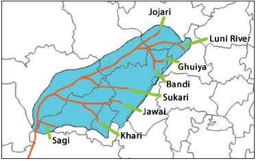
Luni River
- The Luni or the Salt River, is named so because its water is brackish.
- Luni is the only river basin of some significance in Western Rajasthan, which forms the bulk of the arid zone.
- Luni originates from the western slopes of the Aravalli ranges near Ajmer and flows in the southwest direction. It finally drains into the Rann of Kutch (it gets lost in the marsh).
Sharavati River
- The Sharavati River originates and flows entirely within the state of Karnataka.
- The Jog or Gersoppa Falls (289 m), made by the Sharavati River, is the most famous waterfall in India.
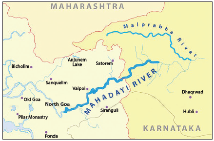
Mahadayi River
- The Mahadayi, also known as the Mhadei or Mandovi in Goa, is a west-flowing river that originates in the Bhimgad Wildlife Sanctuary in the Belagavi district of Karnataka.
- This rain-fed river is formed by several streams converging, making it one of the two major rivers in Goa, alongside the Zuari River.
Mahadayi/Mandovi River Dispute
- The dispute over the Mahadayi River is between Goa and Karnataka.
- It started in the 1980s and grew stronger in the subsequent decades.
- Karnataka has moved to design several dams, canals, and barrages to route the Mahadayi river water to the Malaprabha basin.
- The state claimed that channelling the river water into the Malaprabha basin, a tributary of the Krishna would meet the requirements of the water-scarce districts of Balkot, Gadag, Dharwad, and Belagavi.
| Note: An Inter-state Water Disputes Tribunal has allotted 13.42 thousand million cubic feet of water (TMC) to Karnataka and 1.33 TMC to Maharashtra. Both Karnataka and Goa have contested the order, and the matter is now pending in the apex court. |
Ghaggar River
- The Ghaggar is the most significant river in the inland drainage system. Originating on the lower slopes of the Himalayas, this seasonal stream forms the boundary between Haryana and Punjab.
- It eventually dissipates into the dry sands of Rajasthan near Hanumangarh.
- Earlier, this river was an affluent of the Indus; the old channel’s dry bed is still traceable.
- Its main tributaries are:
- The Tangri,
- The Markanda,
- The Saraswati and
- The Chaitanya.
Desert Rivers
- A few rivers in Rajasthan do not drain into the sea. They drain into salt lakes and get lost in the sand with no outlet to the sea.
- Besides these, some desert rivers flow for some distance and are lost in the desert.
- These are Luni and Machhu, Rupen, Saraswati, Banas, and Ghaggar. These rivers flow for a certain distance before disappearing into the desert sands without an outlet to the sea.
- Some rivers also drain into salt lakes, evaporating and leaving behind salt deposits.
Conclusion
In conclusion, the west-flowing rivers of Peninsular India play a crucial role in the region’s ecology, economy, and cultural identity. From the majestic Narmada and Tapi to the smaller yet significant rivers like the Mahi and Luni, each river contributes uniquely to the landscape and livelihood of the communities they traverse. Their journey through rift valleys, the absence of deltas, and their eventual convergence into estuaries highlight the geological and hydrological complexities of the region. As we continue to navigate the challenges posed by climate change and water disputes, it is essential to recognise the importance of these rivers, not just as water sources but as vital components of India’s rich natural heritage.
What is an Estuary?
- An estuary is a partially enclosed coastal body of water where freshwater from rivers and streams mixes with saltwater from the ocean.
- Primary productivity in estuaries is very high. Fishing is a dominant occupation around estuaries.
- Most of the estuaries are good bird sanctuaries. Estuaries and their surrounding lands act as transition zones from land to sea and from freshwater to saltwater.
- While influenced by tides, estuaries are shielded from the full force of ocean waves, winds, and storms by landforms such as barrier islands or peninsulas.
- These environments are among the most productive on Earth, generating more organic matter annually than equivalent areas of forest, grassland, or agricultural land.
- The tidal, sheltered waters of estuaries support unique communities of plants and animals specifically adapted to life at the sea’s edge.
- Estuaries have significant commercial value, providing economic benefits through tourism, fisheries, and recreational activities.
- Their protected coastal waters support essential public infrastructure, serving as harbors and ports crucial for shipping and transportation.
- Estuaries also offer valuable services. Water draining from uplands carries sediments, nutrients, and pollutants to estuaries. As this water flows through wetlands such as swamps and salt marshes, much of the sediments and pollutants are filtered out.
- Additionally, salt marsh grasses and other estuarine plants help prevent erosion and stabilize shorelines.
Difference between East Flowing Rivers and West Flowing Rivers
| Features | East Flowing Rivers | West Flowing Rivers |
|---|---|---|
Flow Direction | Towards the Bay of Bengal | Towards Arabian Sea |
Length and Course | Generally longer with extensive courses | Generally shorter with less extensives |
| Mouth Formation | Form extensive deltas | Form Estuaries |
| Tributaries | Larger number of tributaries | Fewer tributaries |
| Catchment Areas | Larger catchment areas | Smaller catchment areas |
| Examples | Ganges, Brahmaputra, Godavari, Krishna, Mahanadi | Narmada, Tapi, Mahi, Sabarmati, Mandovi |
| Regions Covered | Primarily northern, central, and eastern India | Primarily western India |
| Characteristics | High volume of water due to numerous tributaries | Less volume of water due to fewer tributaries |
| Extensive alluvial plains and fertile lands | Narrow and deep inlets | |
| Greater potential for agriculture | Less fertile regions |