Syllabus: GS2/International Relations; GS3/Internal Security
Context
- Recently, a team of intrepid Indian mountaineers scaled an unnamed and unclimbed peak in Arunachal Pradesh, decided to name this majestic summit ‘Tsangyang Gyatso Peak’ after the 6th Dalai Lama.
- However, China expressed its long standing claim over the region, which it refers to as Zangnan, and considered any attempt by India as ‘illegal and null and void’.
Historical Background: India-China Boundary Issue
- India shares a 3,488-kilometre-long border with China, which runs along several states: Jammu & Kashmir, Himachal Pradesh, Uttarakhand, Sikkim, and Arunachal Pradesh. This border, known as the Line of Actual Control (LAC), has been a source of tension and occasional conflict between the two nations.
- 1962 Sino-Indian War: The most significant conflict occurred in 1962 when China invaded India across the Himalayan border. India suffered a military defeat, and the war left scars on bilateral relations.
- Post-War Diplomacy: After the war, diplomatic efforts aimed at resolving the boundary issue began. However, progress was slow due to differing perceptions of the border alignment.
- Agreements and Disputes: Over the years, India and China signed several agreements to maintain peace along the border. These included the Agreement on the Maintenance of Peace and Tranquillity (1993) and the Agreement on Political Parameters and Guiding Principles (2005). Despite these agreements, disputes persisted.
| Line of Actual Control (LAC) – The LAC is the demarcation that separates Indian-controlled territory from Chinese-controlled territory. – India considers the LAC to be 3,488 km long, while the Chinese consider it to be only around 2,000 km. – It is divided into three sectors: 1. the eastern sector which spans Arunachal Pradesh and Sikkim (here LAC is called the McMahon Line which is 1,140 km long). 2. the middle sector in Uttarakhand and Himachal Pradesh, and; 3. the western sector in Ladakh. 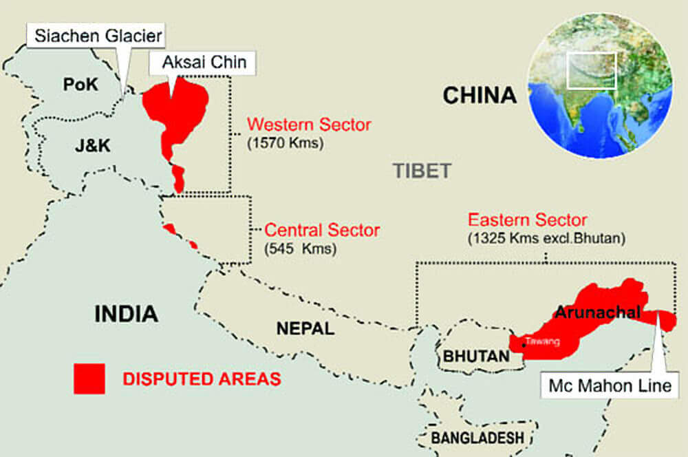 Major friction points along the India-China border – Arunachal Pradesh: This northeastern Indian state is claimed by China as part of its territory and has been a major point of contention between the two countries. – Depsang Plains: This area is located in the northernmost part of Ladakh and has seen incursions by Chinese troops in the past. – Demchok: This area is located in eastern Ladakh and has seen disputes over the boundary between India and China. – Pangong Lake: This area has been a major flashpoint between the two countries, with Chinese troops attempting to change the status quo on the LAC in the region. – Gogra and Hot Springs: These two areas are located in eastern Ladakh and have seen standoffs between Indian and Chinese troops in recent years. |
Recent Developments
- Galwan Clash in Ladakh (2020): A violent clash between Indian and Chinese troops resulted in casualties on both sides. This incident significantly strained bilateral relations.
- Since then, both countries have engaged in disengagement talks to de-escalate tensions. These negotiations aimed to withdraw troops from contentious areas along the LAC.
- The External Affairs Minister of India mentioned that 75% of the disengagement issues had been sorted out. However, it’s essential to clarify that this progress pertains specifically to troop disengagement.
- The broader boundary issue remains unresolved.
- Tawang Region in Arunachal Pradesh: Tawang, strategically located between China and Bhutan, is a significant Indian territory. It lies within the unsettled India-China border.
- The Yangtse plateau within Tawang is crucial for both Indian and Chinese militaries. Its peak altitude of over 5,700 metres provides visibility over much of the region.
- India’s control of the ridgeline along the LAC allows it to prevent Chinese overwatch of roads leading to the Sela Pass — a critical mountain pass that serves as the only access in and out of Tawang.
- Territorial Claim of Arunachal Pradesh: China’s territorial claims over Arunachal Pradesh have been a point of contention for years. Since 2017, China has been renaming places within the region as part of its strategy to assert control.
- India, on the other hand, firmly maintains that Arunachal Pradesh is an integral part of its territory, dismissing China’s renaming efforts as mere semantics.
- The naming of Tsangyang Gyatso Peak adds another layer to this complex geopolitical landscape.
India’s Stance
- India has consistently rejected China’s claims, emphasising that Arunachal Pradesh is an integral part of its sovereign territory, and contends that assigning ‘invented’ names to geographical features does not alter the ground reality.
- For India, Arunachal Pradesh remains a vibrant state with its own cultural heritage, history, and people, regardless of the nomenclature imposed by external forces.
India’s Approach and Mechanisms
- Diplomatic Relations: India established diplomatic relations with the People’s Republic of China in 1950, becoming the first non-socialist bloc country to do so.
- Despite occasional tensions, both sides have engaged in dialogue to manage border issues.
- Mechanisms for Conflict Resolution: India has mechanisms in place to address ‘friction’ related to the international border with China in Arunachal Pradesh.
- Diplomatic channels and bilateral agreements are used to resolve disputes.
- Working Mechanism for Consultation & Coordination (WMCC): It is an institutional framework established to facilitate communication, coordination, and management of border-related issues between India and China. It emerged as a response to the need for improved institutionalised information exchange regarding border matters.
- The discussion was ‘in-depth, constructive and forward-looking’, and both sides agreed to maintain the momentum through established diplomatic and military channels.
Challenges and the Way Forward
- India must promote honest discussions about the history of the boundary dispute and events leading to the 1962 conflict.
- Both countries need to find pragmatic solutions while respecting each other’s territorial integrity.
- India’s stance on the Indo-China border disputes involves a delicate balance of diplomacy, strategic infrastructure development, and safeguarding its territorial interests. As tensions persist, dialogue remains crucial for maintaining peace and stability in the region.
- India and China’s parallel rise as major global players presents a unique challenge in international politics. Balancing competition and cooperation is essential for regional stability and global harmony.
Previous article
Karnataka Withdraws ‘general consent’ to CBI
Next article
Global Innovation Index 2024