Syllabus: GS1/Climatology
Context
- The India Meteorological Department expects a La Niña to set in by late 2024 or early 2025, plus a milder winter due to this delay.
Emergence of La Nina
- Historically, the La Niña has usually formed during the monsoon or the pre-monsoon period, and it has formed only twice between October and December since 1950.
- Predicting La Nina: The oceanic Niño index (ONI) compares the three-month average sea surface temperatures in the East-Central Tropical Pacific with the 30-year average.
- When the difference between the two is 0.5º C or higher, it is an El Niño,
- and when it is –0.5º C or lower, it is a La Niña.
- Currently, it is around –0.3º C. To be classified as a full-fledged La Niña or El Niño, ONI values need to exceed the thresholds at least five times consecutively.
What is La Nina?
- It means Little Girl in Spanish. La Niña is also sometimes called El Viejo, anti-El Niño, or simply “a cold event.”
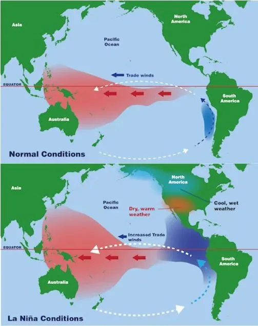
- The trade winds become stronger than usual, pushing more warmer waters towards the Indonesian coast, and making the eastern Pacific Ocean colder than normal.

Impact on Weather Patterns:
- North America: La Niña is often associated with colder winters in the northern U.S. and Canada and warmer, drier conditions in the southern U.S. (such as in the southwestern states).
- South America: La Niña often causes droughts in countries like Peru and Ecuador while bringing more rain to Brazil.
- Asia and Oceania: La Niña tends to bring increased rainfall and a higher risk of flooding to countries like Indonesia, Australia, and parts of Southeast Asia.
Impact on India
- More rainfall in most regions, leading to a stronger monsoon.
- Increased risk of flooding and waterlogging in many parts of the country.
- Cooler temperatures during the post-monsoon and winter months.
- More cyclones in the Indian Ocean, increasing risks for coastal areas.
- Possible agricultural disruptions due to heavy rainfall, floods, and delayed harvesting.
| What is El Nino? – El Niño means Little Boy in Spanish. South American fishermen first noticed periods of unusually warm water in the Pacific Ocean in the 1600s. 1. It is a climate phenomenon characterized by the periodic warming of sea surface temperatures in the central and eastern equatorial Pacific Ocean. 2. During El Niño, trade winds weaken. Warm water is pushed back east, toward the west coast of the Americas and as a result cold water is pushed towards Asia. Impact of El Nino – Low Rainfall: El Niño often correlates with below-average monsoon rainfall in India, leading to droughts in many parts of the country. – Increased Temperature: El Niño also leads to an increase in temperatures across various parts of India. Forest Fires: The drier conditions associated with El Niño increase the risk of forest fires, particularly in regions with dense vegetation. – Water Scarcity: Decreased rainfall during El Niño events lead to water scarcity in many parts of India. – Impact on Fisheries: Changes in sea surface temperatures and ocean currents disrupt fish migration patterns and lead to fluctuations in fish populations. |
Conclusion
- Climate change may increase the frequency and intensity of both La Niña and El Niño events, as rising sea and land temperatures disrupt the Pacific’s balance.
- Thus it would be a welcome development if a La Niña forms now or early next year and continues until the monsoon season. This would mean a less intense summer and more rains for India.
Source: TH
Previous article
News In Short 16-12-2024
Next article
One Candidate, Multiple Constituencies