Syllabus: GS1/ Geography
Context
- Recently a strong earthquake with a magnitude of 7.1 struck in western China near Nepal.
About
- The epicenter of the earthquake was identified in Tingry County in the Shigatse region of Tibet, a significant location as it serves as a ‘gateway’ to Mount Everest.
- The earthquake’s mainshock likely occurred within the Lhasa terrane, a distinct crustal fragment involved in major hydroelectric projects, including the world’s largest hydroelectric dam under construction by China.
What is an Earthquake?
- An earthquake is the shaking of the ground caused by movement beneath the earth’s surface when two blocks slip past each other along a fault.
- This sudden movement releases stored elastic strain energy in the form of seismic waves, which causes ground shaking.
- Epicentre and Hypocenter: The location below the earth’s surface where the earthquake starts is called the hypocenter, and the location directly above it on the surface of the earth is called the epicenter.
- Earthquakes are measured using the Richter scale for magnitude and the Mercalli scale for intensity based on visible damage.
Foreshocks and Aftershocks
- Foreshocks: These are smaller earthquakes that happen in the same place as the larger earthquake that follows.
- The largest, main earthquake is called the mainshock.
- Aftershocks: These are smaller earthquakes that occur afterwards in the same place as the mainshock.
Measuring Earthquakes
- The earthquake events are scaled either according to the magnitude or intensity of the shock.
- Richter Scale: Measures small to medium earthquakes based on seismic wave amplitude.
- The intensity scale, named after Mercalli, considers the visible damage caused by the event.
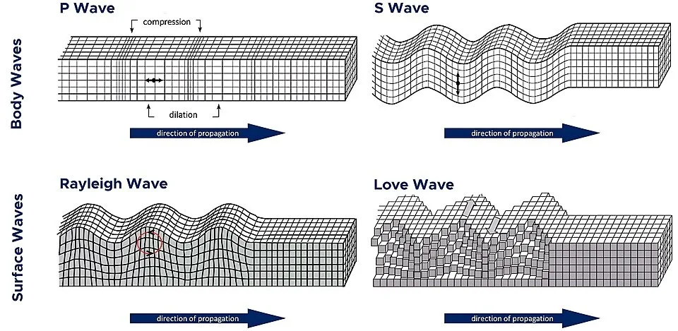
Seismic Waves
- Seismic waves are energy waves generated by an earthquake that travels through the Earth’s layers, causing ground shaking.
- They are mainly classified into two types: body waves and surface waves.
- Body Waves:These waves travel through the interior of the Earth. They are faster and arrive before surface waves during an earthquake.
- Surface waves travel along the Earth’s surface and are slower than body waves but cause the most damage due to their larger amplitude.
Types of Body Waves
- P-Waves (Primary Waves): They are the fastest seismic waves and the first to be recorded by seismographs. They move in a compressional or longitudinal manner.
- P-waves can travel through solids, liquids, and gases.
- S-Waves (Secondary Waves): They move in a transverse manner, where particles move perpendicular to the wave’s direction of propagation.
- S-waves can travel only through solids, as liquids and gases do not support shear stress.
Reason of Earthquake in Himalayas
- Around 50 million years ago, the Indian plate collided with the Eurasian plate, causing rocks to fold and rise to create the Himalayas Mountains.
- The tension between the two plates has continued to build as the Indian plate is still pushing in at around 60 mm/year.
- Earthquakes and tremors occur when the rock formations in the region shift ever so slightly as they adjust to the tension.
Impacts of Earthquake in Himalayas
- Tectonic Activity: The region lies along the convergence zone of the Indian and Eurasian plates.
- The area remains seismically active due to continuous plate movement, which contributes to frequent earthquakes.
- Hydrological Significance: The broader Himalayan region is known as the ‘Third Pole’ due to its vast reserves of water stored in glaciers, lakes, and rivers.
- Earthquakes can destabilize glaciers, alter river courses, and heighten flood risks, threatening millions who rely on Himalayan water sources.
- Strategic and Infrastructural Importance: Earthquakes in such areas could impact major energy generation projects and raise safety concerns.
| India’s Vulnerability to Earthquakes – India is highly vulnerable to earthquakes, with 58.6% of India’s landmass is prone to moderate to very high intensity earthquakes. – India is divided into four seismic zones based on the level of seismic hazard, as outlined by the Bureau of Indian Standards (BIS). 1. Seismic Zone II (Low Seismic Risk): This zone is the least seismically active, with low-intensity earthquakes. It includes parts of the southern peninsula, such as Tamil Nadu, Andhra Pradesh, and parts of Karnataka. 2. Seismic Zone III (Moderate Seismic Risk): This zone experiences moderate seismic activity. This includes regions like Delhi, parts of Maharashtra, Rajasthan, Uttar Pradesh, and Madhya Pradesh. 3. Seismic Zone IV (High Seismic Risk): This zone experiences a high frequency of earthquakes with higher intensity. Areas in the northern and northeastern parts of India, including Jammu and Kashmir, Himachal Pradesh, parts of Uttarakhand, and parts of Assam, Nagaland, and Manipur. 4. Seismic Zone V (Very High Seismic Risk): This zone is the most seismically active, with frequent and intense earthquakes. It includes mainly the Himalayan region, northeastern states, and Gujarat. |
Source: TH
Previous article
Polar Vortex and Winter Storm in USA
Next article
Cashless Treatment Scheme for Road Accident Victims