
In News
- Two United States Senators, have introduced a bipartisan resolution reiterating that the US recognises the McMahon Line as the international boundary between China and India in Arunachal Pradesh.
- The resolution reaffirms India’s well-known and established position that Arunachal Pradesh, which China calls ‘South Tibet’, is an integral part of India.
What is the McMahon Line?
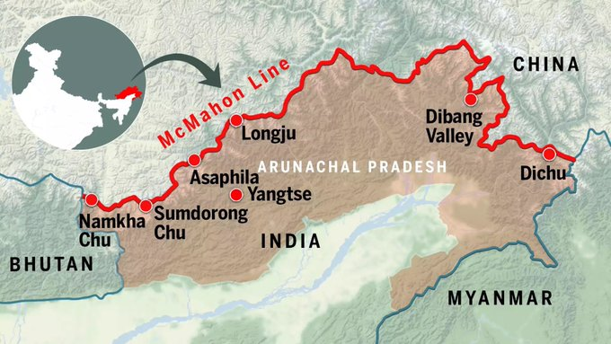
- The McMahon Line serves as the de facto boundary between China and India in the Eastern Sector. It specifically represents the boundary between Arunachal Pradesh and Tibet, from Bhutan in the west to Myanmar in the east.
- China has historically disputed the boundary and claims the state of Arunachal Pradesh as part of the Tibetan Autonomous Region (TAR).
Background
- The McMahon Line was drawn during the Simla Convention of 1914, officially described as the Convention Between Great Britain, China, and Tibet. The line was determined by Sir Henry McMahon, then Foreign Secretary in the Government of British India, and it is called the McMahon Line after his name.
- China was represented at the convention by the government of the Republic of China, which was in power in the mainland from 1912 to 1949.
What is the Shimla Treaty?
- According to the Shimla Treaty, the McMahon Line is the clear boundary line between India and China. On behalf of India, the British rulers considered Tawang of Arunachal Pradesh and the southern part of Tibet as part of India and which was also agreed by the Tibetans. Due to this, the Tawang region of Arunachal Pradesh became part of India.
Why doesn’t China accept the McMahon Line?
- According to China, Tibet has always been a part of its territory, so the representatives of Tibet are not authorised to accept any agreement without Chinese consent. In 1950, China fully occupied Tibet. Now China neither approved nor accepted the McMahon Line.
- China also argues that China was not involved in the Simla Agreement, therefore the Shimla Agreement is not binding on it. China claimed its right on Arunachal Pradesh only after the occupancy of Tibet in 1950.
India’s stand on McMahon Line
- India believes that when the McMahon Line was established in 1914, Tibet was a weak but independent country, so it has every right to negotiate a border agreement with any country.
- Also, when the McMahon Line was drawn, Tibet was not ruled by China. Therefore, the McMahon Line is the clear and legal boundary line between India and China.
- Even after the Chinese occupation over Tibet in 1950, the Tawang region remained an integral part of India.
Current status on the McMahon Line
- India recognizes the McMahon Line and considers it to be the ‘Actual Line of Control (LAC)’ between India and China, while China does not recognize the McMahon Line. China says that the area of the disputed area is 2,000 kilometers while India claims it is 4,000 kilometers.
- This land dispute between India and China is in Tawang (Arunachal Pradesh), which China considers as the Southern part of Tibet. According to the Shimla Agreement it is a part of the Indian state Arunachal Pradesh.

Image: India-China disputed areas
Previous article
IndiaAI Roadmap
Next article
Low-Temperature Thermal Desalination (LTTD)