Syllabus: GS1/Geography; Important Geo-physical Phenomena
Context
- Recently, a 4.0-magnitude earthquake struck Delhi-NCR, causing strong tremors despite its moderate intensity.
- The National Center for Seismology (NCS) attributed the quake to in-situ material heterogeneity—natural geological variations—rather than plate tectonics.
What is ‘In-Situ Material Heterogeneity’?
- Unlike earthquakes caused by tectonic plate movement, this event resulted from variations in the physical properties of the Earth’s crust. Differences in rock type, fluid presence, and stress concentration can create localized seismic activity.
Delhi’s Seismic Risk
- Located in Seismic Zone IV (second highest in India).
- Near the Indian-Eurasian Plate collision zone, where stress builds along fault lines.
- Major Fault Systems:
- Delhi-Haridwar Ridge (extension of the Indian Plate).
- Aravalli Fault System (deep-seated geological structure).
Reasons for Strong Tremors
- Shallow Depth (5 km): Seismic waves had less distance to travel, intensifying the impact.
- Epicenter Within Delhi: The city’s dense urban landscape and high-rise structures amplified the effects.
- Soft Alluvial Soil: The Indo-Gangetic Plain geology enhances wave propagation, making tremors feel stronger.
About Earthquake
- It is the shaking of the ground caused by movement beneath the earth’s surface when two blocks slip past each other along a fault.
- It releases stored elastic strain energy in the form of seismic waves, which causes ground shaking.
- Epicentre: location directly above it on the surface of the earth;
- Hypocenter: location below the earth’s surface where the earthquake;
- Measuring of Earthquake:
- Magnitude: Richter scale;
- Intensity: Mercalli scale;
Earthquake in India
- India is one of the most seismically active regions in the world due to its geographical positioning along the Indian Plate, which is colliding with the Eurasian Plate.
- Earthquakes have historically caused significant devastation in various parts of the country, particularly in the Himalayan belt and other seismically vulnerable regions.
- The growing number of tremors could be linked to shifts in tectonic stress along fault lines, particularly in northern India, and due to the activation of the Almora fault.
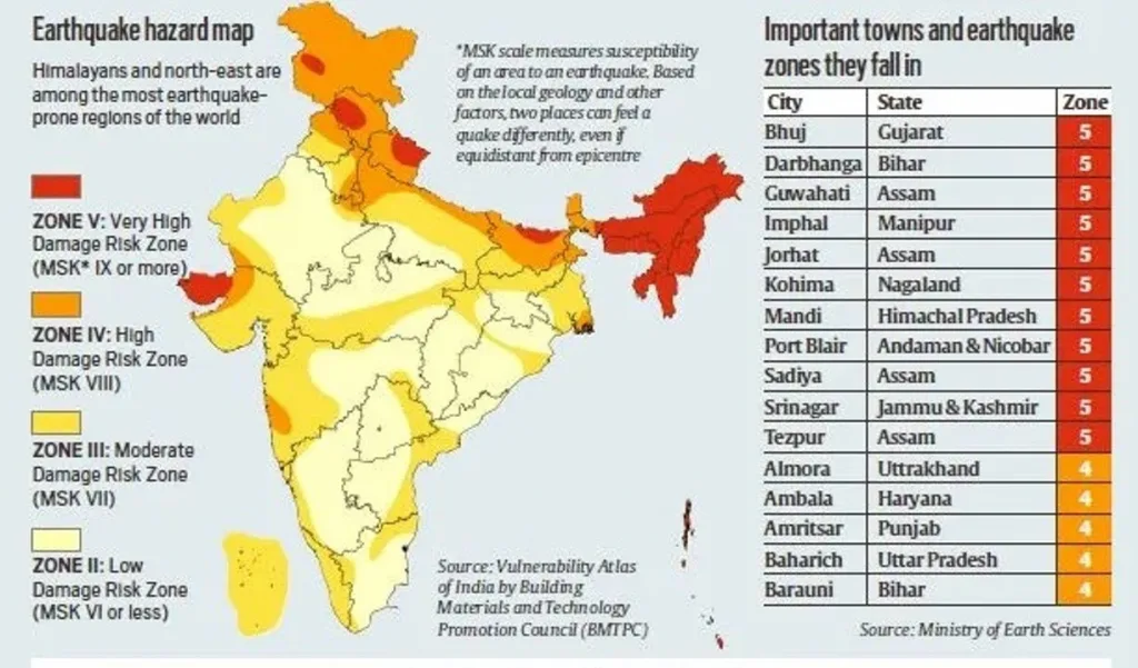
India’s Earthquake Zones and Risk Areas
- India is highly vulnerable to earthquakes, with 58.6% of India’s landmass is prone to moderate to very high intensity earthquakes.
- State-wise ‘Seismic Zonation Map’ of the India country given by Bureau of Indian Standards (BIS).
- Approximately 11% area falls in Zone V, about 18% in Zone IV, about 30% in Zone III and remaining in Zone II.
Seismic Zones in India
- Zone V (Highest Risk): Northeast India, Himachal Pradesh, Uttarakhand, parts of Bihar and Gujarat.
- These are the most vulnerable areas in India, corresponding to MSK-9 levels of intensity or higher.
- Zone IV:Delhi, parts of Maharashtra, Jammu & Kashmir.
- It includes areas that are expected to experience MSK-8-level intensity during an earthquake.
- Zone III: Southern and central states with moderate seismic activity.
- Zone II: Least risk, including parts of southern India.
Key Initiatives
- Seismic Monitoring: The India Meteorological Department (IMD) actively monitors seismic activity and provides real-time updates.
- NDMA Guidelines: The NDMA has issued detailed guidelines for earthquake preparedness, including community awareness programs and structural safety measures.
- Smart Cities and Resilient Infrastructure: Government policies now emphasize earthquake-resistant buildings, particularly in high-risk areas.
Previous article
News In Short-18-02-2025
Next article
Appointment of Chief Election Commissioner