Syllabus: GS3/Disaster Management
Context
- The committee under the chairmanship of Union Home Minister has approved disaster mitigation and capacity building projects for various states.
About
- Landslides pose a significant threat to life and property, especially in hilly and mountainous regions of India.
- The proposal includes the funding from National Disaster Mitigation Fund (NDMF) to mitigate Landslide Risk in 15 States.
- The NDMF is exclusively for the purpose of mitigation projects, aimed at reducing the impact of disasters. It is overseen by the National Disaster Management Authority (NDMA).
- Another proposal is for training and capacity building of Civil Defense volunteers in all States and UT’s under Preparedness and Capacity Building from the funding window of National Disaster Response Fund (NDRF).
Recent Incidents in India
- There has been a sharp rise in landslide events due to extreme weather conditions.
- India faced extreme weather events on 93% of the days in the first nine months — 255 out of 274 days — in 2024 that claimed 3,238 lives, destroyed over 2.35 lakh houses/buildings and affected crops in 3.2 million hectare (mha) of land.
Landslides
- A landslide is a geological phenomenon of sudden movement of rock, earthen materials, and debris down a sloped section of land.
- This movement can be triggered by various natural and man-made factors.
- Intense rain, severe earthquakes, volcanic activity or human activities like construction, deforestation, or changes in cropping patterns can trigger landslides.
Is India prone to landslides?
- India is highly prone to landslides due to its tectonic position.
- The northward movement of the Indian landmass at a rate of 5 cm/year accumulates stress to which natural disasters like landslides are attributed.
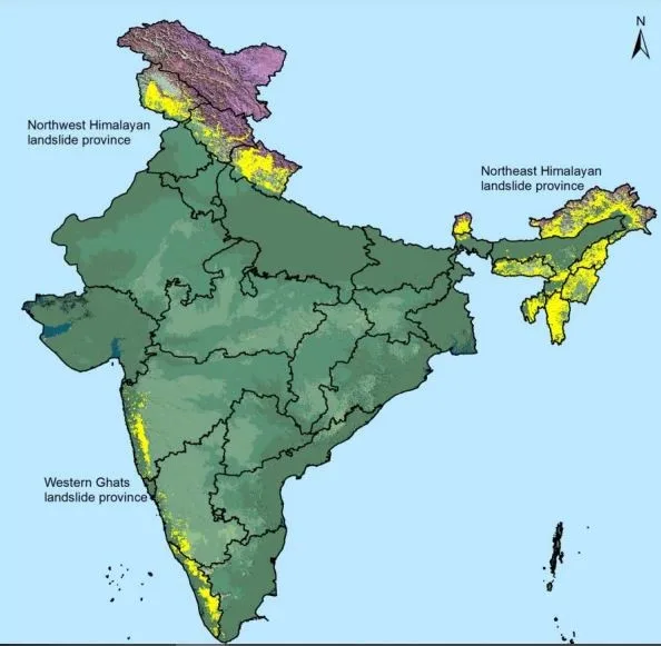
- The Landslide Atlas of India released by the Indian Space Research Organisation (ISRO) listed some of the country’s most vulnerable areas.
- India is among the top five landslide-prone countries in the world.
- Apart from snow-covered areas, around 12.6% of India is vulnerable.
- Among them around 66.5% are in the north-western Himalayas, 18.8% are in the north-eastern Himalayas and around 14.7% are in the Western Ghats region.
- The Northeastern Region (comprises about 50% of the total landslide prone areas in India)
- Areas of Uttarakhand, Himachal Pradesh, and Jammu & Kashmir lying along the Himalayas.
- Areas of Maharashtra, Goa, Karnataka, Kerala, and Tamil Nadu lying along the Western Ghats.
- The Araku region in Andhra Pradesh along the Eastern Ghats.

Measures Taken by India
- The Disaster Management Act, of 2005 provides a comprehensive legal and institutional framework for the management of various disasters including landslides.
- Landslide Hazard Zonation Maps (LHZM): The Geological Survey of India (GSI) and the National Remote Sensing Centre (NRSC) have developed hazard zonation maps to identify landslide-prone areas. These maps help in planning safer land use, infrastructure development, and disaster preparedness.
- The National Landslide Risk Management Strategy (2019) covers all aspects of landslide disaster risk reduction and management, such as hazard mapping, monitoring, and early warning systems.
- The National Institute of Disaster Management (NIDM) has been providing capacity building and other support to various national and state-level disaster management authorities.
- Efforts have been made towards better prediction of weather. E.g. Ensemble Prediction System. This will help predict disasters like landslides.
Conclusion
- While landslides pose a significant challenge, proactive measures can reduce their impact.
- It’s essential to prioritise research, early warning systems, and sustainable land-use practices.
- By doing so, we can reduce the impact of landslides and protect vulnerable communities.
Source: PIB
Next article
News In Short 28-11-2024