Syllabus: GS3/Disaster Management
Context
- Recently, Wayanad of Kerala faced a devastating landslide that claimed over 250 lives. Factors such as Kerala’s fragile ecosystem, extreme rainfall, and increasing population contributed to this disaster. The loss of lives and livelihoods underscores the urgency of understanding and mitigating landslide risks.
About Landslides
- These are defined as the movement of a mass of rock, debris, or earth down a slope. These are a geological phenomenon that involves the sudden and rapid movement of a mass of rock, soil, or debris down a slope under the influence of gravity.
- They are a type of mass wasting, which denotes any downward movement of soil and rock, generally occurring in clay-rich soil.
- In India the entire Himalayan tract, hills/mountains in sub-Himalayan terrains of North-east India, Western Ghats, the Nilgiris in Tamil Nadu and Konkan areas are landslide-prone.
Causes of Landslides
- Natural Causes
- Heavy Rainfall: Heavy rainfall is one of the most common triggers of landslides. It increases pore water pressure as well as the weight of soil by making it saturated.
- Erosion: Clay and vegetation present within the soil or rock act as cohesive elements and help bind particles together. By removing these cohesive elements, erosion makes an area more prone to landslides.
- Earthquakes: Intense ground shaking due to earthquakes causes instability in rocks and soils, thus triggering landslides.
- Volcanic Eruptions: Ash and debris deposited by volcanic eruptions overload slopes while the accompanied seismic activity causes instability.
- Anthropogenic Causes
- Deforestation: By holding soils as well as obstructing the flow of falling debris, vegetation cover plays an important role in preventing landslides in any area. Deforestation takes away this preventive cover and increases vulnerability to landslides.
- Encroachment in Vulnerable Terrains: Of late, humans have been encroaching in landslide-prone areas such as hilly terrains. This has led to increased construction activities in these areas and increased chances of landslides.
- Uncontrolled Excavation: Unauthorised or poorly planned excavation activities, such as mining, quarrying, etc destabilise slopes and increase the chances of landslides.
- Climate Change: Climate change caused by various anthropogenic activities has led to abrupt alterations in precipitation patterns and increased frequency of extreme weather events.
Types (On The Basis of Movement)
- Falls: They refer to the type of landslide that involves the collapse of material from a cliff or steep slope, which then falls down the slope and collects near the base.
- Topples: Under this type of landslide, the falling mass undergoes forward rotation and movement around an axis or point at or near the base.
- Slides: Under this type of landslide, there is a distinct zone of weakness that separates the moving material from a more stable underlying material.
Impacts of Landslides in India
- Loss of Lives and Property: Landslides claim lives, destroy homes, and disrupt communities. Vulnerable populations often suffer the most.
- Infrastructure Damage: Roads, bridges, and other infrastructure can be severely affected, hindering connectivity and emergency response.
- Environmental Degradation: Landslides alter landscapes, erode soil, and impact biodiversity. They also contribute to sedimentation in rivers and reservoirs.
- Economic Costs: Landslides result in direct economic losses due to damage and indirect costs related to recovery efforts.
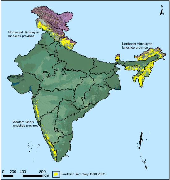
Landslide Prone Areas in India
- ISRO’s National Remote Sensing Centre created a database of landslide-prone regions of India based on events during 1998 – 2022, and released the Landslide Atlas of India.
- In addition to aerial images, high-resolution satellite images captured using ResourceSat-1 and 2, etc., were used to study the landslides.
- As per this atlas, some of the prominent statistics regarding landslides in India are as follows:
- India is among the top five landslide-prone countries in the world.
- Excluding snow-covered areas, around 12.6% of India’s geographical land area is prone to landslides.
- A rough break-up of reported landslides in India is as follows:
- About 66.5% from the North-Western Himalayas;
- About 18.8% from the North-Eastern Himalayas
- About 14.7% from the Western Ghats.
- As per the Landslide Atlas of India, major landslide prone areas in India are as follows:
- The Northeastern Region (comprises about 50% of the total landslide prone areas in India)
- Areas of Uttarakhand, Himachal Pradesh, and Jammu & Kashmir lying along the Himalayas.
- Areas of Maharashtra, Goa, Karnataka, Kerala, and Tamil Nadu lying along the Western Ghats.
- The Araku region in Andhra Pradesh along the Eastern Ghats.
| Landslide Vulnerability in India – According to the Geological Survey of India (GSI) about 0.42 million square km of India’s landmass, or about 13% of its area, spread over 15 states and four Union Territories, is prone to landslides. – About 0.18 million square km, or 42% of this vulnerable area is in the Northeastern region, where the terrain is mostly hilly. – This area is also prone to earthquakes, which too, are a major trigger for landslides. |
Vulnerable Terrain
- Himalayas and Western Ghats: These majestic mountain ranges are among the most vulnerable areas prone to landslides in India. While the Himalayas are well-known for their seismic activity and associated landslides, the Western Ghats—stretching along the western coast of India—are equally susceptible.
- Interestingly, outside of the Himalayas, Kerala stands out as the most vulnerable state. Its unique topography, characterised by steep slopes and abundant rainfall, contributes to this vulnerability.
| Kerala’s Landscape – Around 50% of Kerala’s terrain features slopes exceeding 20 degrees, making it prone to soil erosion and landslides. The loose topsoil overlaying rocks in these areas exacerbates the risk. – Wayanad, nestled in the Western Ghats, exemplifies this vulnerability. Its lush green hills and dense forests create an idyllic landscape but also set the stage for natural disasters. Factors Behind Landslides – Conditioning Factors (related to the local environment and terrain) 1. Soil Topography: The type of soil, its stability, and how it interacts with underlying rock layers play a crucial role. 2. Rocks and Geomorphology: The composition and structure of rocks influence slope stability. 3. Slope Angle: Steep slopes are more prone to landslides. 4. Vegetation Cover: Dense vegetation can stabilise slopes, while deforestation increases the risk. Triggering Factors (These factors initiate landslides) 1. Heavy Rainfall: Excessive rain saturates the soil, reducing its cohesion and triggering slides. 2. Earthquakes: Seismic activity can destabilise slopes. 3. Human Activities: Construction, mining, and deforestation disturb the natural balance, making slopes more susceptible. Role of Climate Change Intensifying Climate Change: Landslides are increasing due to climate change. Extreme weather events, including heavy rainfall, are becoming more frequent. – Rising temperatures can alter soil properties and vegetation dynamics, affecting slope stability. |
Mitigation Measures
- Early Warning Systems: Implementing real-time monitoring and alert systems to notify communities in landslide-prone areas.
- The ‘Global Status of Multi-Hazard Early Warning Systems 2023’ report analyses the latest data one year into the Early Warnings for All Initiative (EW4All) that was formally launched at the COP27 meeting in Sharm El-Sheikh.
- It reveals that 101 countries now have multi-hazard early warning systems, which is based on more complete data from the Sendai Framework Monitor.
- Land Use Planning: Proper zoning and regulations to prevent construction in high-risk zones.
- Vegetation Restoration: Reforestation and afforestation help stabilise slopes.
- Slope Stabilization Techniques: These include retaining walls, terracing, and bioengineering methods.
- Education and Awareness: Educating communities about landslide risks and safety measures.
Measures Taken in India
- The Disaster Management Act, of 2005 provides a comprehensive legal and institutional framework for the management of various disasters including landslides.
- The National Landslide Risk Management Strategy (2019) covers all aspects of landslide disaster risk reduction and management, such as hazard mapping, monitoring, and early warning systems.
- The National Disaster Management Authority (NDMA) has issued Guidelines on Landslide Hazard Management (2009) that outline the steps that should be taken to reduce the risk of landslides.
- The National Institute of Disaster Management (NIDM) has been providing capacity building and other support to various national and state-level disaster management authorities.
- Efforts have been made towards better prediction of weather. E.g. Ensemble Prediction System. This will help predict disasters like landslides.
Suggested Measures
- Gadgil Committee Recommendation
- Ecologically Sensitive Zones: The report recommended classifying 64% of the Western Ghats into Ecologically Sensitive Zones (EEZs) called ESZ 1, ESZ 2 and ESZ 3, based on Ecologically Sensitive Area (ESA).
- Western Ghats Ecology Authority: Under the Environment (Protection) Act, 1986, a professional body to manage the ecology of the region and to ensure its sustainable development was recommended by the committee.
- Ban on Growing Single Commercial Crops: Crops like tea, coffee, cardamom, rubber, banana and pineapple, which have led to “fragmentation of forest, soil erosion, degradation of river ecosystems and toxic contamination of the environment” should be curtailed.
- Community participation: The panel had urged the Ministry of Environment and Forests to take critical steps to involve citizens, including proactive and sympathetic implementation of the provisions of the Community Forest Resources of the Forest Rights Act.
- On the other hand, there is a need to promote terrace farming which can help reduce landslide risks; afforestation and construction of bunds to reduce the flow of falling materials; retaining walls can be built on mountain slopes to stop the falling materials coming down.
- As suggested by the 10th FYP, mitigation measures should be built into the development process itself.
- Traditional knowledge of the local community should be used to tackle such kinds of disasters. Education and training can help ensure the preparedness of the disaster management authorities as well as the local community.
Conclusion
- While landslides pose a significant challenge, proactive measures can reduce their impact. As we continue to grapple with climate change and environmental degradation, understanding and addressing landslide risks remain critical.
- As we grapple with these natural phenomena, it’s essential to prioritise research, early warning systems, and sustainable land-use practices. By doing so, we can reduce the impact of landslides and protect vulnerable communities.
| Daily Mains Practice Question [Q] Discuss the major reasons for landslide vulnerability in India. Highlights the spatial distribution along with key recommendations to minimise the impact of landslides. |
Previous article
Urban Flooding and Human Failure: A Man-Made Disaster